
Saint Mary's County topographic map
Interactive map
Click on the map to display elevation.
About this map
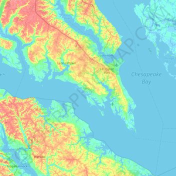
Name: Saint Mary's County topographic map, elevation, terrain.
Location: Saint Mary's County, Maryland, United States (37.89033 -76.87435 38.51371 -76.19967)
Average elevation: 13 m
Minimum elevation: -4 m
Maximum elevation: 62 m
Other topographic maps
Click on a map to view its topography, its elevation and its terrain.
Anne Arundel County
Anne Arundel County, Maryland, United States
Average elevation: 25 m
Lake Bernard Frank
United States > Maryland > Montgomery County
Lake Bernard Frank, Montgomery County, Maryland, United States
Average elevation: 114 m
Rockville
United States > Maryland > Montgomery County
Rockville, Montgomery County, Maryland, United States
Average elevation: 122 m
Chesapeake Forest - Aughty Naughty Complex
United States > Maryland > Wicomico County
Chesapeake Forest - Aughty Naughty Complex, Wicomico County, Maryland, United States
Average elevation: 9 m
Gravely
United States > Maryland > Anne Arundel County
Gravely, Anne Arundel County, Maryland, 21035, United States
Average elevation: 35 m
Mayo
United States > Maryland > Anne Arundel County
Mayo, Anne Arundel County, Maryland, 21106, United States
Average elevation: 2 m
McHenry
United States > Maryland > Garrett County
McHenry, Garrett County, Maryland, 21541, United States
Average elevation: 817 m
Silver Spring
United States > Maryland > Montgomery County > Silver Spring
Silver Spring, Montgomery County, Maryland, United States
Average elevation: 86 m
Dundalk
United States > Maryland > Baltimore County > Dundalk
Dundalk, Baltimore County, Maryland, 21222, United States
Average elevation: 6 m
Mays Chapel
United States > Maryland > Baltimore County > Mays Chapel
Mays Chapel, Baltimore County, Maryland, 21093, United States
Average elevation: 129 m
Middle East
United States > Maryland > Baltimore
Middle East, Baltimore, Maryland, United States
Average elevation: 29 m
Fort Meade
United States > Maryland > Anne Arundel County > Fort Meade
Fort Meade, Anne Arundel County, Maryland, United States
Average elevation: 53 m
Oldtown
United States > Maryland > Oldtown
Oldtown, Allegany County, Maryland, 26722, United States
Average elevation: 194 m
Croom
United States > Maryland > Prince George's County > Croom
Croom, Prince George's County, Maryland, United States
Average elevation: 47 m
Baltimore County
Baltimore County, Maryland, United States
Average elevation: 123 m