
Minsk topographic map
Interactive map
Click on the map to display elevation.
About this map
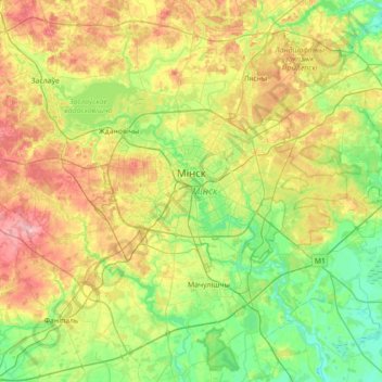
Name: Minsk topographic map, elevation, terrain.
Location: Minsk, Belarus (53.79385 27.37402 53.97179 28.07995)
Average elevation: 222 m
Minimum elevation: 167 m
Maximum elevation: 325 m
Minsk is located on the southeastern slope of the Minsk Hills, a region of rolling hills running from the southwest (upper reaches of the river Nioman) to the northeast– that is, to Lukomskaye Lake in northwestern Belarus. The average altitude above sea level is 220 metres (720 ft). The physical geography of Minsk was shaped over the two most recent ice ages. The Svislach River, which flows across the city from the northwest to the southeast, is in the urstromtal, an ancient river valley formed by water flowing from melting ice sheets at the end of the last Ice Age. There are six smaller rivers within the city limits, all part of the Black Sea basin.
Other topographic maps
Click on a map to view its topography, its elevation and its terrain.
Rahačoŭ District
Rahačoŭ District, Homyel Region, Belarus
Average elevation: 146 m
Rahachow
Belarus > Homyel Region > Rahachow
Rahachow, Rahačoŭ District, Homyel Region, Belarus
Average elevation: 135 m
Тихиничи
Belarus > Homyel Region > Узовский сельский Совет > Тихиничи
Тихиничи, Узовский сельский Совет, Buda-Kashalyova District, Homyel Region, Belarus
Average elevation: 136 m
Ричёв
Belarus > Homel Region > Ричёвский сельский Совет
Ричёв, Ричёвский сельский Совет, Žytkavičy District, Homel Region, Belarus
Average elevation: 125 m
Шатьки
Belarus > Minsk Region > Бобрский сельский Совет
Шатьки, Бобрский сельский Совет, Krupki District, Minsk Region, Belarus
Average elevation: 183 m
Беловежская пуща
Belarus > Brest Region > Каменюкский сельский Совет
Беловежская пуща, Стрела (несуществуюющая), Каменюкский сельский Совет, Kamenets District, Brest Region, Belarus
Average elevation: 163 m
Zhytkavichy
Belarus > Homel Region > Zhytkavichy
Zhytkavichy, Žytkavičy District, Homel Region, Belarus
Average elevation: 137 m
Daugava
Belarus > Vitsebsk Region > Navapolack
Daugava, Navapolack, Vitsebsk Region, 211408, Belarus
Average elevation: 140 m