
Estonia topographic map
Interactive map
Click on the map to display elevation.
About this map
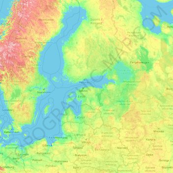
Name: Estonia topographic map, elevation, terrain.
Location: Estonia (51.25238 17.83191 66.25238 32.83191)
Average elevation: 142 m
Minimum elevation: -5 m
Maximum elevation: 1,559 m
Estonia lies on the eastern shores of the Baltic Sea immediately across the Gulf of Finland, on the level northwestern part of the rising East European platform between 57.3° and 59.5° N and 21.5° and 28.1° E. Average elevation reaches only 50 metres (164 ft) and the country's highest point is the Suur Munamägi in the southeast at 318 metres (1,043 ft). There is 3,794 kilometres (2,357 mi) of coastline marked by numerous bays, straits, and inlets. The number of islands and islets is estimated at some 2,355 (including those in lakes). Two of them are large enough to constitute separate counties: Saaremaa and Hiiumaa. A small, recent cluster of meteorite craters, the largest of which is called Kaali is found on Saaremaa, Estonia.
Other topographic maps
Click on a map to view its topography, its elevation and its terrain.
Moka küla
Moka küla, Hiiumaa vald, Hiiu maakond, 92128, Estonia
Average elevation: 10 m
Padise
Padise, Padise küla, Lääne-Harju vald, Harju maakond, 76001, Estonia
Average elevation: 17 m
Puurmani alevik
Puurmani alevik, Põltsamaa vald, Jõgeva maakond, 49014, Estonia
Average elevation: 44 m
Laane küla
Laane küla, Lääne-Harju vald, Harju maakond, 76008, Estonia
Average elevation: 6 m
Vana-Vigala küla
Vana-Vigala küla, Märjamaa vald, Rapla maakond, 78003, Estonia
Average elevation: 15 m
Kivi-Vigala küla
Kivi-Vigala küla, Märjamaa vald, Rapla maakond, 78001, Estonia
Average elevation: 16 m
Luige alevik
Luige alevik, Luige, Kiili vald, Harju maakond, 75401, Estonia
Average elevation: 47 m
Sinimäe alevik
Sinimäe alevik, Narva-Jõesuu linn, Ida-Viru maakond, Estonia
Average elevation: 40 m