
Serbia topographic map
Interactive map
Click on the map to display elevation.
About this map
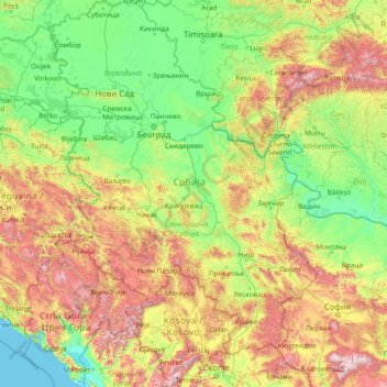
Name: Serbia topographic map, elevation, terrain.
Average elevation: 518 m
Minimum elevation: -3 m
Maximum elevation: 2,773 m
Ancient mountains in the southeast corner of the country belong to the Rilo-Rhodope Mountain system. Elevation ranges from the Midžor peak of the Balkan Mountains at 2,169 metres (7,116 feet) (the highest peak in Serbia, excluding Kosovo) to the lowest point of just 17 metres (56 feet) near the Danube river at Prahovo. The largest lake is Đerdap Lake (163 square kilometres) and the longest river passing through Serbia is the Danube (587.35 kilometres).