
Mourne Mountains West topographic map
Interactive map
Click on the map to display elevation.
About this map
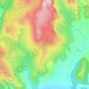
Name: Mourne Mountains West topographic map, elevation, terrain.
Average elevation: 272 m
Minimum elevation: 30 m
Maximum elevation: 633 m
Other topographic maps
Click on a map to view its topography, its elevation and its terrain.
Newry
United Kingdom > Northern Ireland > Newry
Newry, Newry, Mourne and Down District Council, Northern Ireland, United Kingdom
Average elevation: 119 m
Carlingford Lough
United Kingdom > Northern Ireland > Newry > Greencastle
Carlingford Lough, Newry, Northern Ireland, A91 A0V1, United Kingdom
Average elevation: 0 m
Newry
United Kingdom > Northern Ireland > Newry
Newry, County Down, Northern Ireland, BT34 1DG, United Kingdom
Average elevation: 129 m
Ballycross
United Kingdom > Northern Ireland > Newry
Ballycross, Newry, County Down, Northern Ireland, United Kingdom
Average elevation: 89 m
Newry River
United Kingdom > Northern Ireland > Newry
Newry River, Newry, County Down, Northern Ireland, BT35 6BH, United Kingdom
Average elevation: 42 m