
Charleston County topographic map
Interactive map
Click on the map to display elevation.
About this map
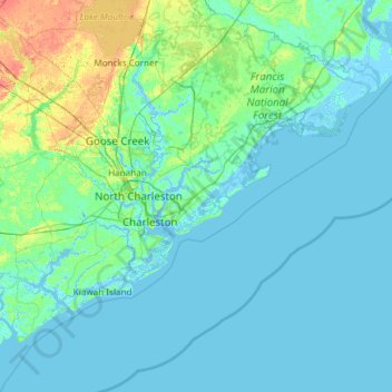
Name: Charleston County topographic map, elevation, terrain.
Location: Charleston County, South Carolina, USA (32.49280 -80.45191 33.21502 -79.25611)
Average elevation: 5 m
Minimum elevation: -4 m
Maximum elevation: 40 m
Other topographic maps
Click on a map to view its topography, its elevation and its terrain.
Red Bluff Crossroads
USA > South Carolina > Red Bluff Crossroads
Red Bluff Crossroads, Horry County, South Carolina, USA
Average elevation: 7 m
Simmonsville
USA > South Carolina > Simmonsville
Simmonsville, Georgetown County, South Carolina, USA
Average elevation: 5 m
Grenadier
USA > South Carolina > Grenadier
Grenadier, Lexington County, South Carolina, 29210, USA
Average elevation: 74 m
Cape Romain National Wildlife Refuge
USA > South Carolina > Awendaw
Cape Romain National Wildlife Refuge, Awendaw, Charleston County, South Carolina, USA
Average elevation: 3 m
Tenmile
USA > South Carolina > Tenmile
Tenmile, Charleston County, South Carolina, 29416, USA
Average elevation: 9 m
Walhalla
USA > South Carolina > Walhalla
Walhalla, Oconee County, South Carolina, 29691, USA
Average elevation: 296 m
Pine Creek
USA > South Carolina > Pine Creek
Pine Creek, Kershaw County, South Carolina, 29020, USA
Average elevation: 73 m