
Stewart Island topographic map
Interactive map
Click on the map to display elevation.
About this map
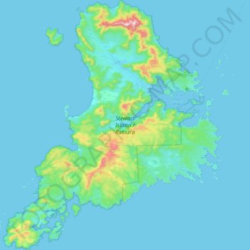
Name: Stewart Island topographic map, elevation, terrain.
Location: Stewart Island, Southland, New Zealand (-47.29000 167.44721 -46.68343 168.22927)
Average elevation: 63 m
Minimum elevation: -2 m
Maximum elevation: 967 m
Although the clay soil is not very fertile, the high rainfall and warm weather mean that the island is densely forested throughout. Native plants include the world's southernmost dense forest of podocarps (southern conifers) and hardwoods such as rātā and kāmahi in the lowland areas with mānuka shrubland at higher elevations. The trees are thought to have become established here since the last ice age from seeds brought across the strait by seabirds, which would explain why the beech trees that are so common in New Zealand, but whose seeds are dispersed by the wind rather than birds, are not found on Stewart Island.
Other topographic maps
Click on a map to view its topography, its elevation and its terrain.
Aramoana
New Zealand > Otago > Dunedin City
Aramoana, Dunedin City, Otago, New Zealand
Average elevation: 26 m
Mount Oval
New Zealand > Canterbury > Hurunui District
Mount Oval, Hurunui District, Canterbury, New Zealand
Average elevation: 506 m
Oyster Island
New Zealand > Nelson > Nelson
Oyster Island, Monaco, Nelson, New Zealand
Average elevation: 0 m
Cone
New Zealand > Manawatū-Whanganui > Tararua District
Cone, Tararua District, Manawatū-Whanganui, New Zealand
Average elevation: 338 m
Omaha Beach
New Zealand > Auckland > Rodney > Omaha
Omaha Beach, Omaha, Rodney, Auckland, New Zealand
Average elevation: 3 m
Rangitīkei District
New Zealand > Manawatū-Whanganui
Rangitīkei District, Manawatū-Whanganui, New Zealand
Average elevation: 538 m
Timaru
New Zealand > Canterbury > Timaru District
Timaru, Timaru District, Canterbury, 7910, New Zealand
Average elevation: 16 m
Mt Baldy
New Zealand > West Coast > Buller District
Mt Baldy, Buller District, West Coast, New Zealand
Average elevation: 1,059 m
Glinks Gully
New Zealand > Northland > Kaipara District
Glinks Gully, Kaipara District, Northland, New Zealand
Average elevation: 43 m
Runciman
New Zealand > Auckland > Franklin > Runciman
Runciman, Franklin, Auckland, 2578, New Zealand
Average elevation: 20 m
Greymouth
New Zealand > West Coast > Grey District > Greymouth
Greymouth, Grey District, West Coast, 7801, New Zealand
Average elevation: 40 m
Chatham Islands
Chatham Islands, Kaiwhata Road, Kaingaroa, Chatham Islands, 8942, New Zealand
Average elevation: 7 m
Hibiscus Coast
New Zealand > Auckland > Hibiscus Coast
Hibiscus Coast, Hibiscus and Bays, Auckland, 0932, New Zealand
Average elevation: 40 m
Dunedin
New Zealand > Otago > Dunedin City
Dunedin, Dunedin City, Otago, 9016, New Zealand
Average elevation: 110 m
Auckland
Auckland, Waitematā, Auckland, 1010, New Zealand
Average elevation: 32 m
South Island
South Island, Ashburton District, Canterbury, New Zealand
Average elevation: 201 m
Motuarohia Island (Roberton Island)
New Zealand > Bay of Islands-Whangaroa Community
Motuarohia Island (Roberton Island), Bay of Islands-Whangaroa Community, Far North District, Northland, New Zealand
Average elevation: 1 m
Little Barrier Island
New Zealand > Auckland > Aotea Great Barrier
Little Barrier Island, Aotea Great Barrier, Auckland, New Zealand
Average elevation: 145 m
White Island
White Island, Bay of Plenty, New Zealand
Average elevation: 38 m
Sandymount
Sandymount, Dunedin, Dunedin City, Otago, New Zealand
Average elevation: 75 m
Mount Wilson
Mount Wilson, Selwyn District, Canterbury, New Zealand
Average elevation: 1,569 m
Christchurch
New Zealand > Canterbury > Christchurch
Christchurch, Christchurch City, Canterbury, New Zealand
Average elevation: 41 m
Dennistoun Glacier
Dennistoun Glacier, Mackenzie District, Canterbury, New Zealand
Average elevation: 2,026 m
Mount Ruapehu
Mount Ruapehu, Ruapehu District, Manawatu-Wanganui, New Zealand
Average elevation: 2,439 m
Aida Glacier
Aida Glacier, Mackenzie District, Canterbury, New Zealand
Average elevation: 1,999 m
Pirongia
New Zealand > Waikato > Pirongia
Pirongia, Waipa District, Waikato, 3844, New Zealand
Average elevation: 44 m
Mount Stewart
Mount Stewart, Manawatu District, Manawatu-Wanganui, New Zealand
Average elevation: 103 m
Queenstown
Queenstown, Queenstown-Lakes District, Otago, 9348, New Zealand
Average elevation: 592 m
Tauranga City
Tauranga City, Bay of Plenty, New Zealand
Average elevation: 55 m
David Glacier
David Glacier, Brewster Track, Westland District, West Coast, New Zealand
Average elevation: 1,648 m
Wellington City
Wellington City, Wellington, New Zealand
Average elevation: 80 m
Southern Alps
Southern Alps, Mackenzie District, Canterbury, New Zealand
Average elevation: 2,832 m
Frances Glacier
Frances Glacier, Rees-Dart Track, Queenstown-Lakes District, Otago, New Zealand
Average elevation: 1,958 m
Baker Glacier
Baker Glacier, Westland District, West Coast, New Zealand
Average elevation: 1,929 m
Rakiura National Park
Rakiura National Park, Southern Circuit Track, Southland, New Zealand
Average elevation: 63 m
Mount Aspiring
Mount Aspiring, Westland District, West Coast, New Zealand
Average elevation: 2,257 m