
Oxford topographic map
Interactive map
Click on the map to display elevation.
About this map
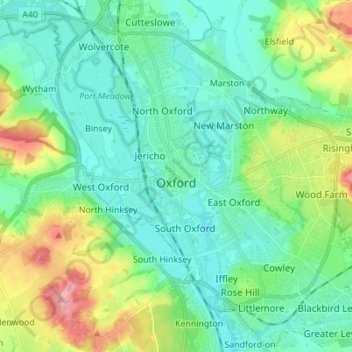
Name: Oxford topographic map, elevation, terrain.
Location: Oxford, Oxfordshire, England, United Kingdom (51.71098 -1.30425 51.79627 -1.17581)
Average elevation: 81 m
Minimum elevation: 50 m
Maximum elevation: 170 m
Other topographic maps
Click on a map to view its topography, its elevation and its terrain.
Charlbury
United Kingdom > England > Oxfordshire > West Oxfordshire > Charlbury
Charlbury, West Oxfordshire, Oxfordshire, England, United Kingdom
Average elevation: 132 m
Swinford
United Kingdom > England > Oxfordshire > Vale of White Horse
Swinford, Vale of White Horse, Oxfordshire, England, OX29 4BZ, United Kingdom
Average elevation: 76 m
Shipton-under-Wychwood
United Kingdom > England > Oxfordshire > West Oxfordshire
Shipton-under-Wychwood, West Oxfordshire, Oxfordshire, England, OX7 6DE, United Kingdom
Average elevation: 131 m
Chipping Norton
United Kingdom > England > Oxfordshire > West Oxfordshire
Chipping Norton, West Oxfordshire, Oxfordshire, England, United Kingdom
Average elevation: 194 m