
Gipuzkoa topographic map
Interactive map
Click on the map to display elevation.
About this map
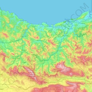
Name: Gipuzkoa topographic map, elevation, terrain.
Location: Gipuzkoa, Autonomous Community of the Basque Country, Spain (42.89507 -2.60271 43.39596 -1.72927)
Average elevation: 396 m
Minimum elevation: -3 m
Maximum elevation: 1,497 m
Other topographic maps
Click on a map to view its topography, its elevation and its terrain.
Álava
Spain > Autonomous Community of the Basque Country
Álava, Autonomous Community of the Basque Country, Spain
Average elevation: 597 m
Amorebieta-Etxano
Spain > Autonomous Community of the Basque Country
Amorebieta-Etxano, Biscay, Autonomous Community of the Basque Country, 48340, Spain
Average elevation: 220 m
Bilbao
Spain > Autonomous Community of the Basque Country
Bilbao, Biscay, Autonomous Community of the Basque Country, Spain
Average elevation: 156 m
Ibarra
Spain > Autonomous Community of the Basque Country > Tolosaldea > Ibarra
Ibarra, Tolosaldea, Gipuzkoa, Autonomous Community of the Basque Country, 20400, Spain
Average elevation: 259 m