
Tilburg topographic map
Interactive map
Click on the map to display elevation.
About this map
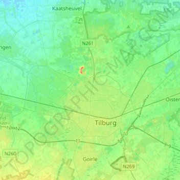
Name: Tilburg topographic map, elevation, terrain.
Location: Tilburg, North Brabant, Netherlands (51.52950 4.94785 51.64166 5.21071)
Average elevation: 11 m
Minimum elevation: -1 m
Maximum elevation: 38 m
Other topographic maps
Click on a map to view its topography, its elevation and its terrain.
Vlijmen
Vlijmen, Heusden, North Brabant, Netherlands
Average elevation: 4 m
's-Hertogenbosch
's-Hertogenbosch, North Brabant, Netherlands
Average elevation: 4 m
Tilburg
Netherlands > North Brabant > Tilburg
Tilburg, North Brabant, Netherlands
Average elevation: 13 m
's-Hertogenbosch
Netherlands > North Brabant > 's-Hertogenbosch
's-Hertogenbosch, North Brabant, Netherlands, 5211JS, Netherlands
Average elevation: 7 m
Eindhoven
Netherlands > North Brabant > Eindhoven
Eindhoven, North Brabant, Netherlands
Average elevation: 20 m
Meierijstad
Netherlands > North Brabant > Meierijstad
Meierijstad, North Brabant, Netherlands
Average elevation: 12 m
Driehuizen
Netherlands > North Brabant > Driehuizen
Driehuizen, North Brabant, Netherlands, 5111, Netherlands
Average elevation: 26 m
Mill
Netherlands > North Brabant > Mill en Sint Hubert
Mill, Mill en Sint Hubert, North Brabant, Netherlands
Average elevation: 14 m
Eindhoven
Netherlands > North Brabant > Eindhoven
Eindhoven, North Brabant, Netherlands
Average elevation: 20 m