
Moneymore topographic map
Interactive map
Click on the map to display elevation.
About this map
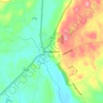
Name: Moneymore topographic map, elevation, terrain.
Average elevation: 71 m
Minimum elevation: 30 m
Maximum elevation: 141 m
Other topographic maps
Click on a map to view its topography, its elevation and its terrain.
Derry/Londonderry
United Kingdom > Northern Ireland > County Londonderry
Derry/Londonderry, County Borough of Londonderry, County Londonderry, Northern Ireland, BT48 6BU, United Kingdom
Average elevation: 88 m
Eagle Hill
United Kingdom > Northern Ireland > County Londonderry
Eagle Hill, County Londonderry, Northern Ireland, BT49 0LG, United Kingdom
Average elevation: 113 m
Mountsandel
United Kingdom > Northern Ireland > County Londonderry > Coleraine
Mountsandel, Fortsandel Avenue, Coleraine, County Londonderry, Northern Ireland, BT52 1JL, United Kingdom
Average elevation: 25 m
Dungannon Fort
United Kingdom > Northern Ireland > County Londonderry > Castlerock > Downhill
Dungannon Fort, Mussenden Road, Downhill, Castlerock, County Londonderry, Northern Ireland, BT51 4RH, United Kingdom
Average elevation: 60 m
Maghera
United Kingdom > Northern Ireland > County Londonderry > Maghera
Maghera, County Londonderry, Northern Ireland, BT46 5AE, United Kingdom
Average elevation: 72 m
Tobermore
United Kingdom > Northern Ireland > County Londonderry > Tobermore
Tobermore, County Londonderry, Northern Ireland, BT45 5QB, United Kingdom
Average elevation: 50 m
Binevenagh
United Kingdom > Northern Ireland > County Londonderry
Binevenagh, County Londonderry, Northern Ireland, BT49 0JB, United Kingdom
Average elevation: 246 m