
McDowell County topographic map
Interactive map
Click on the map to display elevation.
McDowell County
Archaeological excavations performed by Dr. David Moore, during the early 1980s, revealed the earliest inhabitants of McDowell County to be from the Mississippian and Woodland eras. Dr. Moore discovered evidence in an area close to the Catawba River in and around an unusual topographical site known as Round Hill. Cherokee and Catawba Indians were known inhabitants of what is now McDowell County. These early Native Americans lived in this section prior to Juan Pardo's exploration of the region.
About this map
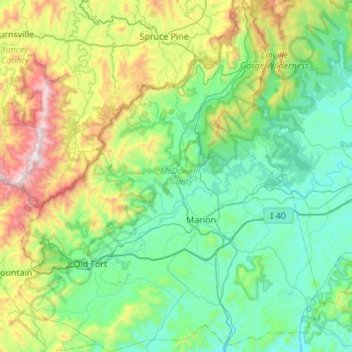
Name: McDowell County topographic map, elevation, terrain.
Location: McDowell County, North Carolina, United States (35.51799 -82.29503 35.96006 -81.82413)
Average elevation: 682 m
Minimum elevation: 291 m
Maximum elevation: 1,998 m
Other topographic maps
Click on a map to view its topography, its elevation and its terrain.
Stone Mountain
United States > North Carolina > Wilkes County
Stone Mountain is the centerpiece of Stone Mountain State Park in North Carolina. It is a dome of exposed granite (specifically a quartz diorite to granodiorite) of Devonian age, which has intruded into the gneiss of the Precambrian Alligator Back Formation. It rises sharply over 600 feet (183 m) above the…
Average elevation: 567 m