
Cherthala topographic map
Interactive map
Click on the map to display elevation.
About this map
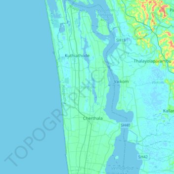
Name: Cherthala topographic map, elevation, terrain.
Location: Cherthala, Alappuzha, Kerala, India (9.58979 76.27946 9.89101 76.40228)
Average elevation: 4 m
Minimum elevation: -2 m
Maximum elevation: 73 m
Other topographic maps
Click on a map to view its topography, its elevation and its terrain.
Perumpetty
India > Kerala > Mallappally
Perumpetty, Mallappally, Pathanamthitta District, Kerala, India
Average elevation: 89 m
Koduvally
India > Kerala > Thamarassery
Koduvally, Thamarassery, Kozhikode district, Kerala, 673572, India
Average elevation: 41 m
Vattappara
India > Kerala > Nedumangad
Vattappara, Nedumangad, Thiruvananthapuram, Kerala, 695028, India
Average elevation: 87 m
Chalavara
India > Kerala > Ottappalam > Chalavara
Chalavara, Ottappalam, Palakkad district, Kerala, 679505, India
Average elevation: 77 m
kuppadi thodu
India > Kerala > Sultan Bathery
kuppadi thodu, Sultan Bathery, Sulthanbathery, Wayanad, Kerala, 673592, India
Average elevation: 889 m
Pamba river
Pamba river, Ranni, Pathanamthitta, Kerala, 689662, India
Average elevation: 616 m
Meesapulimala
Meesapulimala, Idukki, Kerala, 685618, India
Average elevation: 2,221 m