
Clearwater County topographic map
Interactive map
Click on the map to display elevation.
About this map
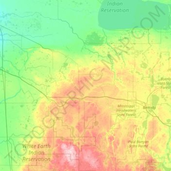
Name: Clearwater County topographic map, elevation, terrain.
Location: Clearwater County, Minnesota, United States (47.15117 -95.58252 48.02188 -95.16927)
Average elevation: 409 m
Minimum elevation: 340 m
Maximum elevation: 593 m
Other topographic maps
Click on a map to view its topography, its elevation and its terrain.
St. Vincent
United States > Minnesota > Kittson County
St. Vincent, Kittson County, Minnesota, 56755, United States
Average elevation: 241 m
Lismore
United States > Minnesota > Nobles County
Lismore, Nobles County, Minnesota, United States
Average elevation: 510 m
Redwood County
Redwood County, Minnesota, United States
Average elevation: 326 m
Le Sueur County
Le Sueur County, Minnesota, United States
Average elevation: 310 m
Lucan
United States > Minnesota > Redwood County
Lucan, Redwood County, Minnesota, United States
Average elevation: 331 m
Clontarf
United States > Minnesota > Swift County
Clontarf, Swift County, Minnesota, 56226, United States
Average elevation: 318 m
Glenville
United States > Minnesota > Glenville
Glenville, Freeborn County, Minnesota, United States
Average elevation: 374 m
Rosemount
United States > Minnesota > Dakota County
Rosemount, Dakota County, Minnesota, 55068, United States
Average elevation: 287 m
Coleraine
United States > Minnesota > Coleraine
Coleraine, Itasca County, Minnesota, 55722, United States
Average elevation: 408 m
Tower
United States > Minnesota > Tower
Tower, Saint Louis County, Minnesota, United States
Average elevation: 427 m