
Kendujhar topographic map
Interactive map
Click on the map to display elevation.
About this map
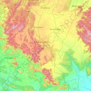
Name: Kendujhar topographic map, elevation, terrain.
Location: Kendujhar, Odisha, India (21.01581 85.18423 22.16259 86.37039)
Average elevation: 371 m
Minimum elevation: 20 m
Maximum elevation: 1,150 m
The highlands consist of clusters of rugged crags and the mountaintops appear to be sharply ridged or peaked, however they have extensive tablelands on their summits. In some areas, isolated hills rise abruptly from the plains, but most areas have a general elevation of over 600m. The highlands form the watershed for a number of rivers, including the Baitarani River.
Other topographic maps
Click on a map to view its topography, its elevation and its terrain.