Geolocate

Anandapur topographic map

Interactive map

Click on the map to display elevation.

About this map

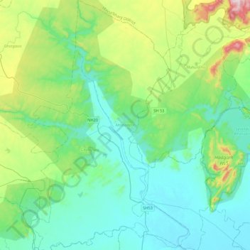
Name: Anandapur topographic map, elevation, terrain.

Location: Anandapur, Kendujhar, Odisha, India (21.13158 86.00088 21.53321 86.24371)

Average elevation: 185 m

Minimum elevation: 26 m

Maximum elevation: 789 m

Other topographic maps

Click on a map to view its topography, its elevation and its terrain.

Junagarh

India > Odisha

Junagarh, Kalahandi District, Odisha, India

Average elevation: 288 m

Uttara

India > Odisha > Pipili

Uttara, Pipili, Puri District, Odisha, 752100, India

Average elevation: 15 m

Joda

India > Odisha

Joda, Kendujhar, Odisha, 758034, India

Average elevation: 513 m

Kendujhar

India > Odisha

Kendujhar, Odisha, India

Average elevation: 371 m

Angul

India > Odisha > Angul

Angul, Anugul, Odisha, 759122, India

Average elevation: 121 m

Eastern Ghats

India > Odisha

Eastern Ghats, Gajapati, Odisha, India

Average elevation: 1,130 m