
Clarence Valley Council topographic map
Interactive map
Click on the map to display elevation.
About this map
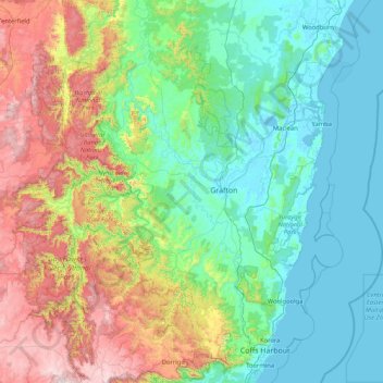
Name: Clarence Valley Council topographic map, elevation, terrain.
Location: Clarence Valley Council, New South Wales, Australia (-30.41890 152.16812 -28.96997 153.37572)
Average elevation: 357 m
Minimum elevation: -2 m
Maximum elevation: 1,540 m
Other topographic maps
Click on a map to view its topography, its elevation and its terrain.
Blue Mountains
A sandstone plateau dominated by a landscape of eucalyptus forests, the Blue Mountains are located at the top of a 470-million-year-old quartzite. In the Permian period, a shallow sea covered the region, when rivers brought shales, siltstones and mudstones. Then during the Mesozoic period, rivers dumped vast…
Average elevation: 566 m
Mount Kembla
Australia > New South Wales > Wollongong
The summit of Mount Kembla has an elevation of 534 metres (1,752 ft) above sea level.
Average elevation: 227 m