
Wels topographic map
Interactive map
Click on the map to display elevation.
About this map
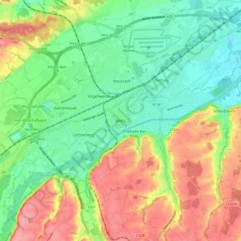
Name: Wels topographic map, elevation, terrain.
Location: Wels, Upper Austria, 4600, Austria (48.11655 13.98438 48.19655 14.06438)
Average elevation: 343 m
Minimum elevation: 301 m
Maximum elevation: 400 m
Wels is in the Hausruckviertel at an elevation of 317 m. From north to south, it extends over 9.5 km, from west to east over 9.6 km. 3.4% of the area is covered with forest, 23.5% is used for agriculture.