Geolocate
👉 Easily get elevation data in JSON, GeoTIFF and KML formats using Elevation API
Thank you for supporting this site ❤️
Make a donation

Gear up for your next adventure:

As an Amazon Associate, this site earns from qualifying purchases at no extra cost to you.

Dublin 11 topographic map

Click on the map to display elevation.

Gear up for your next adventure:

As an Amazon Associate, this site earns from qualifying purchases at no extra cost to you.

About this map

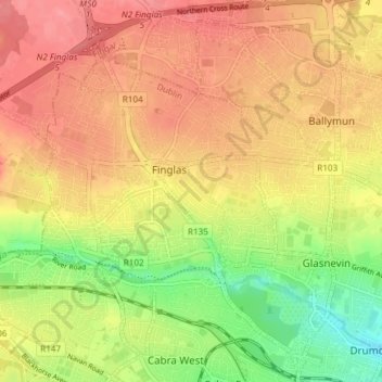
Name: Dublin 11 topographic map, elevation, terrain.

Location: Dublin 11, Leinster, Ireland (53.36435 -6.33286 53.40885 -6.26304)

Average elevation: 53 m

Minimum elevation: 6 m

Maximum elevation: 85 m

Ireland trails, hiking, mountain biking, running and outdoor activities

👉 Easily get elevation data in JSON, GeoTIFF and KML formats using Elevation API
Thank you for supporting this site ❤️
Make a donation

Gear up for your next adventure:

As an Amazon Associate, this site earns from qualifying purchases at no extra cost to you.

Other topographic maps

Click on a map to view its topography, its elevation and its terrain.

Cork

Ireland > County Cork > Cork

Average elevation: 94 m

Bohermeen

Ireland > County Meath

Average elevation: 74 m

Galway City

Ireland > Galway City

Average elevation: 26 m

Longford

Ireland > County Longford

Average elevation: 57 m

Galtymore

Ireland > County Limerick > The Municipal District of Cappamore — Kilmallock

Galtymore or Galteemore (Irish: Cnoc Mór na nGaibhlte, meaning 'big hill of the Galtees') is a mountain in the province of Munster, Ireland. At 917.9 metres (3,011 ft 6 in), it is one of Ireland's highest mountains, being the 12th-highest on the Arderin list, and 14th-highest on the Vandeleur-Lynam list.…

Average elevation: 594 m

Thank you for supporting this site ❤️
Make a donation

Gear up for your next adventure:

As an Amazon Associate, this site earns from qualifying purchases at no extra cost to you.

Newtown Forbes

Ireland > County Longford

Average elevation: 56 m

Glengarriff

Ireland > County Cork

Average elevation: 66 m

Castledermot

Ireland > County Kildare

Average elevation: 83 m

Blackrock

Ireland > County Louth

Average elevation: 5 m

Knockanore

Ireland > County Kerry

Average elevation: 155 m

Thank you for supporting this site ❤️
Make a donation

Gear up for your next adventure:

As an Amazon Associate, this site earns from qualifying purchases at no extra cost to you.

Waterfall

Ireland > County Cork

Average elevation: 83 m

Moylussa

Ireland > County Clare

Average elevation: 372 m

Ahane

Ireland > County Limerick > Limerick

Average elevation: 31 m

Grangemockler

Ireland > County Tipperary

Average elevation: 165 m

Magheracloone

Ireland > County Monaghan

Average elevation: 57 m

Thank you for supporting this site ❤️
Make a donation

Gear up for your next adventure:

As an Amazon Associate, this site earns from qualifying purchases at no extra cost to you.

John's River

Ireland > County Waterford

Average elevation: 23 m

Bawnboy

Ireland > County Cavan

Average elevation: 63 m

Kinvarra

Ireland > County Galway

Average elevation: 11 m

Ticknevin

Ireland > County Kildare

Average elevation: 80 m

Wild Nephin Wilderness

Ireland > County Mayo

Average elevation: 117 m

Thank you for supporting this site ❤️
Make a donation

Gear up for your next adventure:

As an Amazon Associate, this site earns from qualifying purchases at no extra cost to you.

Stradone

Ireland > County Cavan

Average elevation: 117 m

Abbey Island

Ireland > County Kerry

Average elevation: 12 m

Tydavnet

Ireland > County Monaghan

Average elevation: 88 m

Wine Coos

Ireland

Average elevation: 32 m

Ballinahown

Ireland > County Westmeath

Average elevation: 49 m

Thank you for supporting this site ❤️
Make a donation

Gear up for your next adventure:

As an Amazon Associate, this site earns from qualifying purchases at no extra cost to you.

Brandon Hill

Ireland > County Kilkenny

Brandon Hill (Irish: Cnoc Bhréanail) is the highest mountain in County Kilkenny, Ireland, with an elevation of 515 m (1,690 ft) and prominence at 448 m (1,470 ft). The South Leinster Way, a long-distance trail, meandering through the Barrow Valley and traverses Brandon Hill. The village of Graiguenamanagh and…

Average elevation: 294 m

Clare

Ireland > County Galway

Average elevation: 14 m

Leades Cross

Ireland > County Cork

Average elevation: 218 m

Annacarty

Ireland > County Tipperary

Average elevation: 130 m

New Twopothouse

Ireland > County Cork

Average elevation: 114 m

Thank you for supporting this site ❤️
Make a donation

Gear up for your next adventure:

As an Amazon Associate, this site earns from qualifying purchases at no extra cost to you.

Kilpedder

Ireland > County Wicklow

Average elevation: 99 m

Curraghmore

Ireland > County Kerry

Average elevation: 528 m

Ballymount

Ireland > County Dublin > Clondalkin

Average elevation: 68 m

Cliffs of Moher

Ireland > County Clare

Average elevation: 55 m

Sandyford

Ireland > County Dublin

Average elevation: 121 m

Thank you for supporting this site ❤️
Make a donation

Gear up for your next adventure:

As an Amazon Associate, this site earns from qualifying purchases at no extra cost to you.

River Brosna

Ireland > County Westmeath > Mullingar

Average elevation: 100 m

Allow

Ireland > County Cork

Average elevation: 119 m

Malin Head

Ireland > County Donegal

Average elevation: 4 m

Coragh Lough

Ireland > County Cavan

Average elevation: 98 m

Thank you for supporting this site ❤️
Make a donation

Gear up for your next adventure:

As an Amazon Associate, this site earns from qualifying purchases at no extra cost to you.

Abbeyshrule

Ireland > County Longford

Average elevation: 66 m

Timahoe

Ireland > County Laois

Average elevation: 146 m

Stepaside

Ireland > County Dublin

Average elevation: 183 m

Donabate Beach

Ireland > County Dublin

Average elevation: 2 m

Geevagh

Ireland > County Sligo

Average elevation: 92 m

Thank you for supporting this site ❤️
Make a donation

Gear up for your next adventure:

As an Amazon Associate, this site earns from qualifying purchases at no extra cost to you.

Castleblakeney

Ireland > County Galway

Average elevation: 74 m

Donabate Beach

Ireland > County Dublin

Average elevation: 2 m

Cliffs of Moher

Ireland > County Clare

Average elevation: 55 m

Lambay Island

Ireland > County Dublin

Lambay Island is the largest island off the east coast of Ireland. It covers about 2.5 km2 (0.97 sq mi). The highest point – a hill known as Knockbane – rises to 126 m (413 ft). The island's high ground lies to the east and aside from Knockbane includes Heath Hill and Tinian Hill, and in the extreme…

Average elevation: 14 m

Thank you for supporting this site ❤️
Make a donation

Gear up for your next adventure:

As an Amazon Associate, this site earns from qualifying purchases at no extra cost to you.

Inch

Ireland > County Clare

Average elevation: 63 m

Rosenallis

Ireland > County Laois

Average elevation: 114 m

Dún Laoghaire

Ireland > County Dublin

Average elevation: 21 m

Bantry

Ireland > County Cork

Average elevation: 67 m

Aherla

Ireland > County Cork

Average elevation: 91 m

Thank you for supporting this site ❤️
Make a donation

Gear up for your next adventure:

As an Amazon Associate, this site earns from qualifying purchases at no extra cost to you.

Mangerton

Ireland > County Kerry

Mangerton Mountain's height and topographic prominence, qualifies it to meet the British Isles Marilyn classification, as well as the Arderin, Simm and Hewitt classifications. Mangerton Mountain ranks as the 10th-highest mountain in Ireland on the MountainViews Online Database, 100 Highest Irish Mountains,…

Average elevation: 657 m

Lough Con

Ireland > County Donegal

Average elevation: 43 m

Glenmalure

Ireland > County Wicklow

Average elevation: 295 m

Ballinacurra

Ireland > County Cork

Average elevation: 18 m

Thank you for supporting this site ❤️
Make a donation

Gear up for your next adventure:

As an Amazon Associate, this site earns from qualifying purchases at no extra cost to you.

Drumanoo Head

Ireland > County Donegal

Average elevation: 8 m

Bealad Cross Roads

Ireland > County Cork

Average elevation: 94 m

Sandyford

Ireland > County Dublin

Average elevation: 121 m

Little Skellig

Ireland > County Kerry

Average elevation: 0 m

Thank you for supporting this site ❤️
Make a donation

Gear up for your next adventure:

As an Amazon Associate, this site earns from qualifying purchases at no extra cost to you.

Howth

Ireland > County Dublin

Average elevation: 8 m

Skellig

Ireland > County Cork

Average elevation: 122 m

Hollyford

Ireland > County Tipperary

Average elevation: 282 m

Conor Pass

Ireland > County Kerry

Average elevation: 293 m

Johnstown Castle

Ireland > County Wexford

Average elevation: 58 m

Pettigo

Ireland > County Donegal

Average elevation: 80 m

Colman's Point

Ireland > County Clare

Average elevation: 14 m

Cornelscourt

Ireland > County Dublin

Average elevation: 59 m

Dungarvan

Ireland > County Waterford

Average elevation: 30 m

Muckish

Ireland > County Donegal

Average elevation: 323 m

Rathowen

Ireland > County Westmeath

Average elevation: 71 m

Glenfarne

Ireland > County Leitrim

Average elevation: 90 m

Termon River

Ireland > County Roscommon

Average elevation: 75 m

Thank you for supporting this site ❤️
Make a donation

Gear up for your next adventure:

As an Amazon Associate, this site earns from qualifying purchases at no extra cost to you.

Black Rock Mountain

Ireland > County Wexford

Average elevation: 380 m

Knockma

Ireland > County Galway

Average elevation: 53 m

Loughshinny

Ireland > County Dublin

Average elevation: 14 m

Rathdangan

Ireland > County Wicklow

Evidence of habitation is shown by a Bronze Age burial cist, a fort dating from at least the eight-century and a Norman moat at Killamoat. A 1668 survey records 18 houses in the village. Due to its mountainous elevation, in the severe winters of 1947, 1963 and 1982, Rathdangan was isolated for weeks. In 1985…

Average elevation: 228 m

Owning

Ireland > County Kilkenny

Average elevation: 97 m

Thank you for supporting this site ❤️
Make a donation

Gear up for your next adventure:

As an Amazon Associate, this site earns from qualifying purchases at no extra cost to you.

Kilmichael Hill

Ireland > County Wexford

Average elevation: 169 m

Stepaside

Ireland > County Dublin

Average elevation: 183 m

Benbulbin

Ireland > County Sligo

Average elevation: 257 m

Thank you for supporting this site ❤️
Make a donation

Gear up for your next adventure:

As an Amazon Associate, this site earns from qualifying purchases at no extra cost to you.

Rose Ville

Ireland > County Wicklow

Average elevation: 81 m

Maulin

Ireland > County Wicklow

Average elevation: 367 m

Rathfarnham

Ireland > County Dublin

Average elevation: 56 m

Keeper Hill

Ireland > County Tipperary

Average elevation: 431 m

Coolea

Ireland > County Cork

Average elevation: 204 m

Bartlemy

Ireland > County Cork

Average elevation: 98 m

Ballyvourney

Ireland > County Cork

Average elevation: 200 m

River Lee (North Channel)

Ireland > County Cork > Cork

Average elevation: 32 m

Lettermore

Ireland > County Galway

Average elevation: 8 m

Courtown

Ireland > County Wexford

Average elevation: 15 m

Thank you for supporting this site ❤️
Make a donation

Gear up for your next adventure:

As an Amazon Associate, this site earns from qualifying purchases at no extra cost to you.