
Town of Onondaga topographic map
Interactive map
Click on the map to display elevation.
About this map
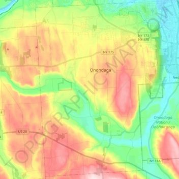
Name: Town of Onondaga topographic map, elevation, terrain.
Average elevation: 266 m
Minimum elevation: 120 m
Maximum elevation: 451 m
Other topographic maps
Click on a map to view its topography, its elevation and its terrain.
Ulster
United States of America > New York
Ulster, New York, United States of America
Average elevation: 343 m
Saint Lawrence
United States of America > New York
Saint Lawrence, New York, United States of America
Average elevation: 239 m
Chenango County
United States of America > New York
Chenango County, New York, United States of America
Average elevation: 442 m
Parish
United States of America > New York > Parish
Parish, Town of Parish, Oswego County, New York, 13131, United States of America
Average elevation: 147 m
Essex County
United States of America > New York
Essex County, New York, United States of America
Average elevation: 418 m
Chautauqua County
United States of America > New York
Chautauqua County, New York, United States of America
Average elevation: 328 m
Westchester
United States of America > New York
Westchester, New York, United States of America
Average elevation: 95 m
Farmingville
United States of America > New York > Farmingville
Farmingville, Suffolk County, New York, 11738, United States of America
Average elevation: 47 m
Saratoga County
United States of America > New York
Saratoga County, New York, United States of America
Average elevation: 218 m
Niagara Falls
United States of America > New York > Niagara Falls
Niagara Falls, Niagara County, New York, United States of America
Average elevation: 180 m
Suffolk County
United States of America > New York
Suffolk County, New York, United States of America
Average elevation: 36 m