
Sutton topographic map
Interactive map
Click on the map to display elevation.
About this map
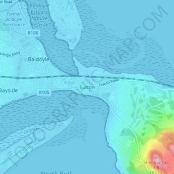
Name: Sutton topographic map, elevation, terrain.
Location: Sutton, Fingal, Dublin 13, Leinster, D13 A7X4, Ireland (53.36939 -6.12981 53.40939 -6.08981)
Average elevation: 8 m
Minimum elevation: -5 m
Maximum elevation: 154 m
Other topographic maps
Click on a map to view its topography, its elevation and its terrain.
Ballyseedy Wood
Ballyseedy Wood, Ballyseedy ED, Tralee Municipal District, County Kerry, Munster, Ireland
Average elevation: 20 m
Dromore West
Dromore West, Ballymote-Tubbercurry Municipal District, County Sligo, Connacht, Ireland
Average elevation: 51 m
Cork
Ireland > County Cork > Cork
Cork, County Cork, Munster, T12 T997, Ireland
Average elevation: 94 m
Johnstown
Johnstown, The Municipal District of Naas, County Kildare, Leinster, W91 Y3CP, Ireland
Average elevation: 97 m
Cloonkeenkerrill
Cloonkeenkerrill, Colmanstown ED, Ballinasloe Municipal District, County Galway, Connacht, Ireland
Average elevation: 88 m
Colmanstown
Colmanstown, Killofin ED, West Clare Municipal District, County Clare, Munster, Ireland
Average elevation: 24 m
Morristown
Morristown, Rathmore ED, The Municipal District of Naas, County Kildare, Leinster, Ireland
Average elevation: 113 m
Galway City
Galway, Galway City, County Galway, Connacht, H91 YD86, Ireland
Average elevation: 26 m
Gort
Gort, Loughrea Municipal District, County Galway, Connacht, H91 R5F9, Ireland
Average elevation: 27 m
Kilkenny
Kilkenny, The Municipal District of Kilkenny City, County Kilkenny, Leinster, Ireland
Average elevation: 61 m
Cordarragh
Cordarragh, Headford ED, Tuam Municipal District, County Galway, Connacht, Ireland
Average elevation: 20 m
Comeragh
Comeragh, The Municipal District of Comeragh, County Waterford, Munster, Ireland
Average elevation: 215 m
Sligo
Sligo, Sligo Municipal Borough District, County Sligo, Connacht, Ireland
Average elevation: 21 m
Ballincollig
Ireland > County Cork > Cork
Ballincollig, Cork, County Cork, Munster, P31 TW88, Ireland
Average elevation: 62 m
Adare
Ireland > County Limerick > The Municipal District of Adare — Rathkeale
Adare, The Municipal District of Adare — Rathkeale, County Limerick, Munster, Ireland
Average elevation: 12 m
Lanesborough
Lanesborough, Ballymahon Municipal District, County Longford, Leinster, Ireland
Average elevation: 41 m
Summerhill
Summerhill, Summerhill ED, The Municipal District of Trim, County Meath, Leinster, Ireland
Average elevation: 86 m
Curraghboy
Curraghboy, Rockhill Electoral Division, Athlone Municipal District, County Roscommon, Connacht, N37 EK20, Ireland
Average elevation: 69 m
Kilcurriv Eighter
Kilcurriv Eighter, Killower ED, Tuam Municipal District, County Galway, Connacht, Ireland
Average elevation: 48 m
Cahir
Cahir, The Municipal District of Cahir — Cashel, County Tipperary, Munster, Ireland
Average elevation: 58 m
Callanagh Lower
Callanagh Lower, Drumlumman ED, Ballyjamesduff Municipal District, County Cavan, Ulster, Ireland
Average elevation: 85 m
Mount Lucas
Mount Lucas, Esker ED, The Municipal District of Edenderry, County Offaly, Leinster, R35 XW10, Ireland
Average elevation: 76 m
Gorteennakilla
Gorteennakilla, Youghalarra, The Municipal District of Nenagh, County Tipperary, Munster, Ireland
Average elevation: 57 m
Lettermore
Lettermore, Lettermore ED, Conamara Municipal District, County Galway, Connacht, Ireland
Average elevation: 8 m
Ballyhaunis
Ballyhaunis, Claremorris-Swinford Municipal District, County Mayo, Connacht, F35 NF82, Ireland
Average elevation: 87 m
Lough Bane
Lough Bane, Crosskeys ED, The Municipal District of Kells, County Westmeath, County Meath, Leinster, Ireland
Average elevation: 130 m
Upper Lough Bray
Upper Lough Bray, Powerscourt ED, The Municipal District of Bray, County Wicklow, Leinster, Ireland
Average elevation: 496 m
Broadlough
Broadlough, Ardee Rural ED, The Municipal District of Ardee, County Louth, Leinster, Ireland
Average elevation: 34 m
Moorock
Moorock, Ballycumber ED, The Municipal District of Tullamore, County Offaly, Leinster, Ireland
Average elevation: 64 m
Barnadown
Barnadown, Aghaviller, The Municipal District of Callan — Thomastown, County Kilkenny, Leinster, Ireland
Average elevation: 212 m
Shronowen
Shronowen, Shronowen ED, Listowel Municipal District, County Kerry, Munster, Ireland
Average elevation: 27 m
Pembrokestown
Pembrokestown, Waterford City Metropolitan District, County Waterford, Munster, X91 R6CA, Ireland
Average elevation: 57 m
Smithstown
Smithstown, Ballinlough ED, The Municipal District of Kells, County Meath, Leinster, Ireland
Average elevation: 121 m
Ballinaclogh
Ballinaclogh, Glenealy ED, The Municipal District of Wicklow, County Wicklow, Leinster, Ireland
Average elevation: 108 m
Pollduff
Pollduff, Loughrea Municipal District, County Galway, Connacht, Ireland
Average elevation: 219 m
Kiltole
Kiltole, Figart ED, Lifford-Stranorlar Municipal District, County Donegal, Ireland
Average elevation: 49 m
Durrow
Durrow, The Municipal District of Tullamore, County Offaly, Leinster, R35 X865, Ireland
Average elevation: 66 m
Inchigeelagh
Inchigeelagh, Municipal District of Macroom, County Cork, Munster, P12 W864, Ireland
Average elevation: 135 m