
Ústí nad Labem topographic map
Interactive map
Click on the map to display elevation.
About this map
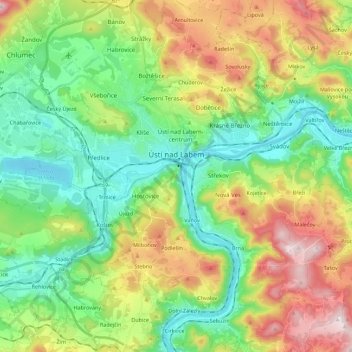
Name: Ústí nad Labem topographic map, elevation, terrain.
Average elevation: 315 m
Minimum elevation: 121 m
Maximum elevation: 674 m
Ústí nad Labem is located about 65 kilometres (40 mi) north of Prague and 45 km (28 mi) south of Dresden in Germany. It lies mostly in a hilly landscape of the Central Bohemian Uplands, but it also extends into the Most Basin in the northwest. The highest peak is Široký Vrch with an elevation of 659 m (2,162 ft). The city is situated at the confluence of the Elbe and Bílina river. Half of Lake Milada lies in the municipal territory. The southern part of the territory lies in the České Středohoří Protected Landscape Area.
Other topographic maps
Click on a map to view its topography, its elevation and its terrain.
Žatec
Czechia > Northwest > Ústecký kraj
Žatec, okres Louny, Ústecký kraj, Northwest, 438 01, Czechia
Average elevation: 254 m