
Sutton Coldfield topographic map
Interactive map
Click on the map to display elevation.
About this map
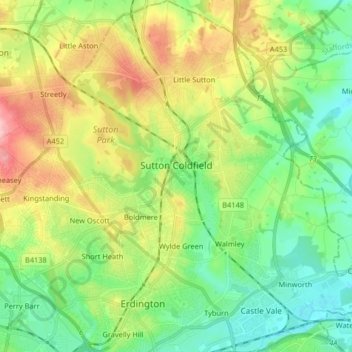
Name: Sutton Coldfield topographic map, elevation, terrain.
Average elevation: 124 m
Minimum elevation: 75 m
Maximum elevation: 214 m
Other topographic maps
Click on a map to view its topography, its elevation and its terrain.
Cotteridge
United Kingdom > England > Birmingham
Cotteridge, Birmingham, West Midlands Combined Authority, England, B30 3EE, United Kingdom
Average elevation: 154 m