
Newport County topographic map
Interactive map
Click on the map to display elevation.
About this map
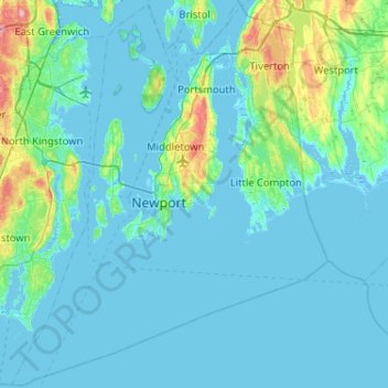
Name: Newport County topographic map, elevation, terrain.
Location: Newport County, Rhode Island, United States of America (41.30402 -71.51156 41.69050 -71.09996)
Average elevation: 14 m
Minimum elevation: -7 m
Maximum elevation: 130 m
The county consists of Aquidneck Island, Conanicut Island, Prudence Island, and the easternmost portion of the state on the mainland. The highest point in the county is Pocasset Hill, 320 feet (98 m) above sea level, located in Tiverton. The lowest elevation is at sea level.
Other topographic maps
Click on a map to view its topography, its elevation and its terrain.
Providence
United States of America > Rhode Island > Providence
Providence, Providence County, Rhode Island, United States of America
Average elevation: 19 m
Providence County
United States of America > Rhode Island > Providence > Smithfield
Providence County, Rhode Island, United States of America
Average elevation: 108 m