
Tipaturu topographic map
Interactive map
Click on the map to display elevation.
About this map
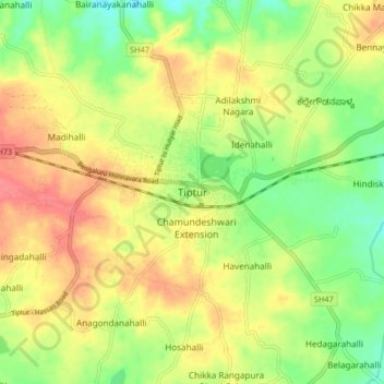
Name: Tipaturu topographic map, elevation, terrain.
Average elevation: 855 m
Minimum elevation: 823 m
Maximum elevation: 886 m
Tiptur has been surrounded by from the west side Arsikere and channarayapatna. from the east side Chikkanayakana halli, Gubbi, Turuvekere. Tiptur is approximately 73 km (45 mi) west of Tumkur along National Highway 206 (now renumbered as National Highway 48). It is at a distance of 130 km (81 mi) northwest from the state capital, Bangalore. It lies on the Bangalore-Miraj railway line. Tiptur has an average elevation of 861 metres (2,825 ft). The average temperature in summer is 34 °C (93 °F) and in winter is 20 °C (68 °F).