
Castlewellan topographic map
Interactive map
Click on the map to display elevation.
About this map
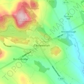
Name: Castlewellan topographic map, elevation, terrain.
Average elevation: 105 m
Minimum elevation: 14 m
Maximum elevation: 265 m
Other topographic maps
Click on a map to view its topography, its elevation and its terrain.
Castlewellan Forest Park
United Kingdom > Northern Ireland > Castlewellan
Castlewellan Forest Park, Clarkill, Castlewellan, County Down, Northern Ireland, United Kingdom
Average elevation: 145 m