
La Spezia topographic map
Interactive map
Click on the map to display elevation.
About this map
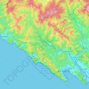
Name: La Spezia topographic map, elevation, terrain.
Location: La Spezia, Liguria, Italy (44.02324 9.46574 44.44157 10.07151)
Average elevation: 354 m
Minimum elevation: -3 m
Maximum elevation: 1,810 m
Because of its topography, the city is not exposed to winds from the north, which lap western Liguria, but to those from the southeast. These may bring heavy rain and they can reach 80 kilometres per hour (50 mph), in rare cases causing the blocking of the port. The only northern wind reaching the city is the north-eastern Grecale, common during incursions of Arctic air, when the cold air flowing over the warmer Tyrrhenian sea triggers the formation of low pressures, draining the colder and heavier air trapped in the Po Valley, behind the Apennine Mountains.
Other topographic maps
Click on a map to view its topography, its elevation and its terrain.