
Make a donation
Gear up for your next adventure:
As an Amazon Associate, this site earns from qualifying purchases at no extra cost to you.
Darien topographic map
Click on the map to display elevation.
Make a donation
Gear up for your next adventure:
As an Amazon Associate, this site earns from qualifying purchases at no extra cost to you.
Darien
On its east side, Long Neck Point Road stretches south beginning near the Ring's End Landing bridge and terminating at the southerly most tip of land. This area is somewhat inland and away from the eastern shoreline and at a relatively high elevation above the water. The west coast of Long Neck runs along Goodwives River and includes Pear Tree Point. Situated on Noroton Harbor, Pear Tree Point includes a public beach (Pear Tree Point Beach Park) and a private club (Darien Boat Club). Pear Tree Point Road, begins at the Ring's End Landing bridge, runs south along the western side of Long Neck adjacent to "The Gut" and to outer Noroton Harbor. This charming route hugs the shoreline at an elevation close enough to the tides such that storm conditions can bring the water level over the road. Approximately half-way south along the peninsula, Pear Tree Point Road turns abruptly to the east, ninety degrees, heading uphill and connecting to Long Neck Point Road, distinguishing Long Neck from Long Neck Point.
Make a donation
Gear up for your next adventure:
As an Amazon Associate, this site earns from qualifying purchases at no extra cost to you.
About this map
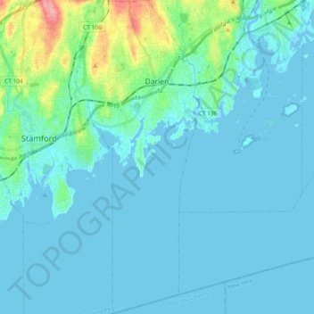
Name: Darien topographic map, elevation, terrain.
Average elevation: 12 m
Minimum elevation: -2 m
Maximum elevation: 98 m
Make a donation
Gear up for your next adventure:
As an Amazon Associate, this site earns from qualifying purchases at no extra cost to you.
Other topographic maps
Click on a map to view its topography, its elevation and its terrain.
Ponus
United States > Connecticut > Western Connecticut Planning Region > New Canaan
Average elevation: 77 m