
Gwynedd topographic map
Interactive map
Click on the map to display elevation.
About this map
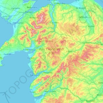
Name: Gwynedd topographic map, elevation, terrain.
Location: Gwynedd, Wales, United Kingdom (52.53679 -4.80439 53.28113 -3.43678)
Average elevation: 199 m
Minimum elevation: -1 m
Maximum elevation: 1,035 m
Other topographic maps
Click on a map to view its topography, its elevation and its terrain.
Snowdonia National Park
United Kingdom > Wales > Gwynedd
Snowdonia National Park, Gwynedd, Wales, United Kingdom
Average elevation: 218 m