
Lusk topographic map
Interactive map
Click on the map to display elevation.
About this map
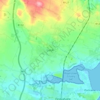
Name: Lusk topographic map, elevation, terrain.
Location: Lusk, Fingal, County Dublin, Leinster, K45 K650, Ireland (53.48558 -6.20581 53.56558 -6.12581)
Average elevation: 26 m
Minimum elevation: -1 m
Maximum elevation: 107 m
Other topographic maps
Click on a map to view its topography, its elevation and its terrain.
Lusk
Ireland > County Dublin > Lusk
Lusk, Lusk ED, Lusk, Fingal, County Dublin, Leinster, Ireland
Average elevation: 24 m