
Benbradagh topographic map
Interactive map
Click on the map to display elevation.
About this map
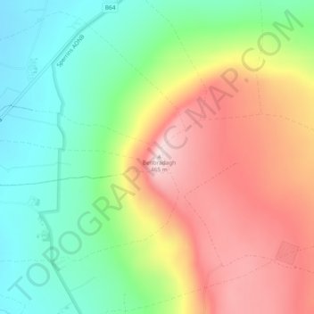
Name: Benbradagh topographic map, elevation, terrain.
Average elevation: 252 m
Minimum elevation: 85 m
Maximum elevation: 461 m
Other topographic maps
Click on a map to view its topography, its elevation and its terrain.
River Foyle
United Kingdom > Northern Ireland > Londonderry/Derry
River Foyle, Londonderry/Derry, County Londonderry, Northern Ireland, BT47 1DH, United Kingdom
Average elevation: 61 m
Magilligan
United Kingdom > Northern Ireland > Londonderry/Derry
Magilligan, Aughil, Londonderry/Derry, County Londonderry, Northern Ireland, United Kingdom
Average elevation: 81 m
Lough Foyle
United Kingdom > Northern Ireland > Londonderry/Derry
Lough Foyle, Londonderry/Derry, County Londonderry, Northern Ireland, United Kingdom
Average elevation: 61 m
Termonbacca
United Kingdom > Northern Ireland > Londonderry/Derry
Termonbacca, Londonderry/Derry, County Londonderry, Northern Ireland, United Kingdom
Average elevation: 74 m
Mullaghmore
United Kingdom > Northern Ireland > Londonderry/Derry
Mullaghmore, Londonderry/Derry, County Londonderry, Northern Ireland, United Kingdom
Average elevation: 389 m
Loughermore
United Kingdom > Northern Ireland > Londonderry/Derry
Loughermore, Londonderry/Derry, County Londonderry, Northern Ireland, United Kingdom
Average elevation: 294 m
Edenballymore
United Kingdom > Northern Ireland > Londonderry/Derry
Edenballymore, Londonderry/Derry, County Londonderry, Northern Ireland, United Kingdom
Average elevation: 41 m