
Sawtooth Mountains topographic map
Interactive map
Click on the map to display elevation.
About this map
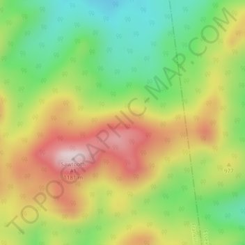
Name: Sawtooth Mountains topographic map, elevation, terrain.
Location: Sawtooth Mountains, Franklin County, New York, USA (44.19278 -74.11354 44.19288 -74.11344)
Average elevation: 927 m
Minimum elevation: 722 m
Maximum elevation: 1,168 m
Other topographic maps
Click on a map to view its topography, its elevation and its terrain.
Atlantic Basin
Atlantic Basin, New York County, New York, 11231, USA
Average elevation: 4 m
Avalanche Lake
Avalanche Lake, Avalanche Pass Trail, Essex County, New York, USA
Average elevation: 1,066 m
Spike Island
Spike Island, Rye, Westchester County, New York, 10587, USA
Average elevation: 50 m
Joshua
USA > New York > Town of Onondaga > Joshua
Joshua, Town of Onondaga, Onondaga County, New York, 13110, USA
Average elevation: 332 m
Livingston Island
Livingston Island, Town of Philipstown, Putnam County, New York, 10922, USA
Average elevation: 156 m
Big Bear Mountain
Big Bear Mountain, Town of Johnsburg, Warren County, New York, USA
Average elevation: 616 m
Flat Top Mountain
Flat Top Mountain, Franklin County, New York, USA
Average elevation: 568 m
Mount Warren
Mount Warren, Town of Bovina, Delaware County, New York, USA
Average elevation: 677 m
Roosevelt Island
USA > New York > New York City
Roosevelt Island, Manhattan Community Board 8, New York County, New York City, New York, 10044, USA
Average elevation: 13 m