
Boulder County topographic map
Interactive map
Click on the map to display elevation.
About this map
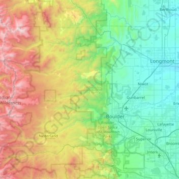
Name: Boulder County topographic map, elevation, terrain.
Location: Boulder County, Colorado, United States (39.91289 -105.69436 40.26297 -105.05280)
Average elevation: 2,308 m
Minimum elevation: 1,487 m
Maximum elevation: 4,340 m
Rocky Mountain National Park is in Boulder County, Larimer County, and Grand County. Longs Peak, the park's highest summit at 4,345 meters (14,255 feet) elevation, is located in Boulder County.