
Dugi otok topographic map
Interactive map
Click on the map to display elevation.
About this map
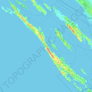
Name: Dugi otok topographic map, elevation, terrain.
Location: Dugi otok, Zadar County, Croatia (43.86489 14.81850 44.17734 15.22626)
Average elevation: 11 m
Minimum elevation: -4 m
Maximum elevation: 315 m
Other topographic maps
Click on a map to view its topography, its elevation and its terrain.
Općina Starigrad
Općina Starigrad, Zadar County, 23244, Croatia
Average elevation: 608 m
Tulove Grede
Tulove Grede, Općina Jasenice, Zadar County, Croatia
Average elevation: 852 m