
Doons topographic map
Interactive map
Click on the map to display elevation.
About this map
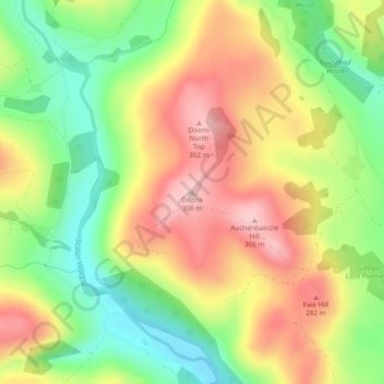
Name: Doons topographic map, elevation, terrain.
Average elevation: 202 m
Minimum elevation: 99 m
Maximum elevation: 308 m
Other topographic maps
Click on a map to view its topography, its elevation and its terrain.
Fingland
United Kingdom > Scotland > Dumfries and Galloway
Fingland, Dumfries and Galloway, Scotland, DG11 2LD, United Kingdom
Average elevation: 206 m
Durisdeer
United Kingdom > Scotland > Dumfries and Galloway
Durisdeer, Dumfries and Galloway, Scotland, DG3 5BJ, United Kingdom
Average elevation: 270 m
Eskdalemuir
United Kingdom > Scotland > Dumfries and Galloway
Eskdalemuir, Dumfries and Galloway, Scotland, DG13 0QF, United Kingdom
Average elevation: 246 m
Moniaive
United Kingdom > Scotland > Dumfries and Galloway
Moniaive, Dumfries and Galloway, Scotland, DG3 4HN, United Kingdom
Average elevation: 179 m