
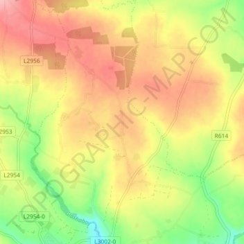
Ballynabortagh topographic map
Interactive map
Click on the map to display elevation.
About this map
Name: Ballynabortagh topographic map, elevation, terrain.
Average elevation: 153 m
Minimum elevation: 86 m
Maximum elevation: 208 m
Other topographic maps
Click on a map to view its topography, its elevation and its terrain.
Coosane
Ireland > County Cork > Municipal District of Cobh
Coosane, Watergrasshill, Municipal District of Cobh, County Cork, Munster, Ireland
Average elevation: 108 m
Lysaghtstown
Ireland > County Cork > Municipal District of Cobh
Lysaghtstown, Carrigtohill ED, Municipal District of Cobh, County Cork, Munster, Ireland
Average elevation: 81 m
Tullagreen
Ireland > County Cork > Municipal District of Cobh
Tullagreen, Carrigtohill ED, Municipal District of Cobh, County Cork, Munster, Ireland
Average elevation: 12 m
Ballynanelagh
Ireland > County Cork > Municipal District of Cobh > Knockraha
Ballynanelagh, Knockraha, Municipal District of Cobh, County Cork, Munster, Ireland
Average elevation: 113 m