
County Meath topographic map
Click on the map to display elevation.
County Meath
Meath is largely flat and much of the county lies below 100 m (330 ft) above sea-level. The minor hills in the far west of the county at Loughcrew, and in the north at Carrickleck are the only upland areas of any significance. Slieve na Calliagh, at just 276 m (906 ft) in height, is the highest point in the county, making it the second lowest county top in Ireland. Carrickleck Hill, near the Cavan border, is the second highest peak in Meath, at 173 m (568 ft). The Hill of Tara is located south of Navan and, although just 155 m (509 ft) in height, is the most prominent feature in the local topography, commanding a panoramic view of the surrounding area.
About this map
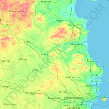
Name: County Meath topographic map, elevation, terrain.
Location: County Meath, Leinster, Ireland (53.38187 -7.34362 53.91754 -6.21280)
Average elevation: 64 m
Minimum elevation: -1 m
Maximum elevation: 322 m
Ireland trails, hiking, mountain biking, running and outdoor activities
Other topographic maps
Click on a map to view its topography, its elevation and its terrain.
Swords
Ireland > County Dublin > Swords
The medieval town developed in a linear pattern along Main Street, in a roughly north-south direction. Swords has one of the best examples of this settlement pattern in the Dublin region. The round tower, 26m in height, is also an indicator of early Christian settlement. The Irish high king Brian Boru is said…
Average elevation: 28 m
Nephin
In Leabhar Fiachrach, a topographical and genealogical tract written by Giolla Iosa Mor Mac Fhirbhisigh about 1400, the areas early peoples and families are listed thus.
Average elevation: 404 m
Kilcruaig
Ireland > County Limerick > The Municipal District of Cappamore — Kilmallock
Average elevation: 200 m
Greystones
Greystones is located south of the site of an ancient castle of the Barony of Rathdown. There was a hamlet which, like Rathdown Castle, was known as Rathdown, and which appeared on a 1712 map. This site occupied an area now known as the Grove, north of Greystones harbour, but only the ruins of a chapel, St.…
Average elevation: 49 m
Limerick
Limerick's climate is classified as temperate oceanic (Köppen Cfb). Met Éireann maintains a climatological weather station at Shannon Airport, 20 kilometres west of the city in County Clare. Shannon Airport records an average of 977 millimetres of precipitation annually, most of which is rain. Limerick has a…
Average elevation: 54 m