
Schiphol topographic map
Interactive map
Click on the map to display elevation.
About this map
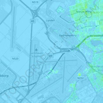
Name: Schiphol topographic map, elevation, terrain.
Location: Schiphol, Haarlemmermeer, North Holland, Netherlands (52.28294 4.70592 52.36801 4.81708)
Average elevation: -2 m
Minimum elevation: -8 m
Maximum elevation: 11 m
Other topographic maps
Click on a map to view its topography, its elevation and its terrain.
Volendam
Volendam, Edam-Volendam, North Holland, Netherlands
Average elevation: 0 m
Badhoevedorp
Badhoevedorp, Haarlemmermeer, North Holland, Netherlands
Average elevation: -2 m
Halfweg
Netherlands > North Holland > Halfweg
Halfweg, Haarlemmermeer, North Holland, Netherlands
Average elevation: 0 m
Zaandam
Netherlands > North Holland > Zaandam
Zaandam, Zaanstad, North Holland, Netherlands
Average elevation: 0 m
Sint Pancras
Netherlands > North Holland > Sint Pancras
Sint Pancras, Langedijk, North Holland, Netherlands
Average elevation: 1 m
Zaanstad
Netherlands > North Holland > Zaanstad
Zaanstad, North Holland, Netherlands
Average elevation: 0 m
Zandvoort
Netherlands > North Holland > Zandvoort
Zandvoort, North Holland, Netherlands
Average elevation: 4 m
IJmuiden
Netherlands > North Holland > Velsen
IJmuiden, Velsen, North Holland, Netherlands
Average elevation: 5 m