
Chester topographic map
Interactive map
Click on the map to display elevation.
About this map
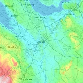
Name: Chester topographic map, elevation, terrain.
Average elevation: 61 m
Minimum elevation: -1 m
Maximum elevation: 486 m
Other topographic maps
Click on a map to view its topography, its elevation and its terrain.
Whitegate
United Kingdom > England > Cheshire West and Chester
Whitegate, Cheshire West and Chester, England, CW8 2BH, United Kingdom
Average elevation: 49 m