
Atlantic County topographic map
Interactive map
Click on the map to display elevation.
About this map
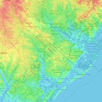
Name: Atlantic County topographic map, elevation, terrain.
Location: Atlantic County, New Jersey, USA (39.26205 -74.98522 39.72991 -74.23182)
Average elevation: 15 m
Minimum elevation: -4 m
Maximum elevation: 64 m
Other topographic maps
Click on a map to view its topography, its elevation and its terrain.
Tinton Falls
USA > New Jersey > Tinton Falls
Tinton Falls, Monmouth County, New Jersey, USA
Average elevation: 23 m
Bellview
USA > New Jersey > Bellview
Bellview, Burlington County, New Jersey, 08077, USA
Average elevation: 8 m