
Munaily District topographic map
Interactive map
Click on the map to display elevation.
About this map
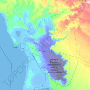
Name: Munaily District topographic map, elevation, terrain.
Location: Munaily District, Mangystau Region, 130600, Kazakhstan (43.17020 51.02868 44.14628 52.00923)
Average elevation: 46 m
Minimum elevation: -130 m
Maximum elevation: 419 m
Other topographic maps
Click on a map to view its topography, its elevation and its terrain.
Aktau
Kazakhstan > Mangystau Region > Aktau
Aktau, Актау Г.А., Mangystau Region, 130000, Kazakhstan
Average elevation: -15 m