
Campoalegre topographic map
Interactive map
Click on the map to display elevation.
About this map
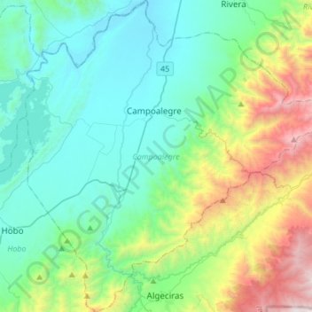
Name: Campoalegre topographic map, elevation, terrain.
Location: Campoalegre, Huila, Colombia (2.51027 -75.43892 2.78109 -75.17014)
Average elevation: 1,072 m
Minimum elevation: 458 m
Maximum elevation: 3,076 m
Other topographic maps
Click on a map to view its topography, its elevation and its terrain.
Quinchana
Colombia > Huila > San Agustín
Quinchana, San Agustín, Sur, Huila, RAP (Especial) Central, Colombia
Average elevation: 2,082 m