
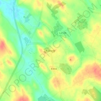
Kilcogy topographic map
Interactive map
Click on the map to display elevation.
About this map
Name: Kilcogy topographic map, elevation, terrain.
Average elevation: 89 m
Minimum elevation: 64 m
Maximum elevation: 121 m
Other topographic maps
Click on a map to view its topography, its elevation and its terrain.
Callanagh Lower
Callanagh Lower, Drumlumman ED, Ballyjamesduff Municipal District, County Cavan, Ulster, Ireland
Average elevation: 85 m
Virginia
Virginia, Virginia ED, Ballyjamesduff Municipal District, County Cavan, Ireland
Average elevation: 98 m
Crossdoney
Crossdoney, Ballyjamesduff Municipal District, County Cavan, H12 K727, Ireland
Average elevation: 67 m
Bailieborough
Bailieborough, Bailieborough ED, Bailieborough-Cootehill Municipal District, County Cavan, A82 NX86, Ireland
Average elevation: 162 m
Shercock
Shercock, Shercock ED, Bailieborough-Cootehill Municipal District, County Cavan, Ulster, A81 DK60, Ireland
Average elevation: 117 m
Mount Nugent
Mount Nugent, Ballyjamesduff Municipal District, County Cavan, Ulster, Ireland
Average elevation: 74 m
Ballyjamesduff
Ballyjamesduff, Ballyjamesduff Municipal District, County Cavan, Ulster, A82 CT95, Ireland
Average elevation: 118 m
Ballyconnell
Ballyconnell, Ballyconnell ED, Cavan-Belturbet Municipal District, County Cavan, Ulster, H14 EC99, Ireland
Average elevation: 68 m
Cootehill
Cootehill, Bailieborough-Cootehill Municipal District, County Cavan, Ulster, Ireland
Average elevation: 89 m
Cornafean
Cornafean, Ballyjamesduff Municipal District, County Cavan, Ulster, Ireland
Average elevation: 82 m
Killashandra
Killashandra, Killashandra ED, Cavan-Belturbet Municipal District, County Cavan, Ulster, Ireland
Average elevation: 62 m
Loch Gowna (Scrabby)
Loch Gowna (Scrabby), Scrabby ED, Ballyjamesduff Municipal District, County Cavan, Ulster, Ireland
Average elevation: 80 m
Snugborough
Snugborough, Ballyconnell ED, Cavan-Belturbet Municipal District, County Cavan, Ulster, Ireland
Average elevation: 174 m
Tullycoe
Tullycoe, Larah North ED, Bailieborough-Cootehill Municipal District, County Cavan, Ulster, Ireland
Average elevation: 96 m
Togher or Danesfort Demesne
Togher or Danesfort Demesne, Killykeen ED, Cavan-Belturbet Municipal District, County Cavan, Ulster, Ireland
Average elevation: 64 m
Corfad
Corfad, Stradone ED, Bailieborough-Cootehill Municipal District, County Cavan, Ireland
Average elevation: 130 m
Lisdaran
Lisdaran, Cavan Rural ED, Cavan-Belturbet Municipal District, County Cavan, Ulster, Ireland
Average elevation: 73 m
Cormeen
Cormeen, Larah South ED, Bailieborough-Cootehill Municipal District, County Cavan, Ulster, Ireland
Average elevation: 133 m
Monaghanoose
Monaghanoose, Drumanespick ED, Bailieborough-Cootehill Municipal District, County Cavan, Ireland
Average elevation: 140 m
Bailieborough
Bailieborough, Bailieborough-Cootehill Municipal District, County Cavan, Ulster, A82 NX86, Ireland
Average elevation: 163 m
Cleffin
Cleffin, Killinkere ED, Bailieborough-Cootehill Municipal District, County Cavan, Ulster, Ireland
Average elevation: 128 m
Bailieborough
Ireland > County Cavan > Bailieborough
Bailieborough, Bailieborough-Cootehill Municipal District, County Cavan, A82 NX86, Ireland
Average elevation: 169 m
Seefin
Seefin, Drumanespick ED, Bailieborough-Cootehill Municipal District, County Cavan, Ireland
Average elevation: 194 m
Kilnavert
Kilnavert, Ballymagauran ED, Cavan-Belturbet Municipal District, County Cavan, Ireland
Average elevation: 68 m
Killaghaduff
Killaghaduff, Swanlinbar ED, Cavan-Belturbet Municipal District, County Cavan, Ireland
Average elevation: 91 m
Drumgart
Drumgart, Ardue ED, Cavan-Belturbet Municipal District, County Cavan, Ireland
Average elevation: 55 m
Cornamucklagh
Ireland > County Cavan > Cornamucklagh
Cornamucklagh, Crossdoney ED, Ballyjamesduff Municipal District, County Cavan, H12K727, Ireland
Average elevation: 61 m
Bailieborough-Cootehill Municipal District
Bailieborough-Cootehill Municipal District, County Cavan, Ulster, Ireland
Average elevation: 122 m
Carrickallen
Carrickallen, Larah North ED, Bailieborough-Cootehill Municipal District, County Cavan, Ireland
Average elevation: 185 m
Dunaree
Dunaree, Kingscourt ED, Bailieborough-Cootehill Municipal District, County Cavan, Ireland
Average elevation: 115 m
Laraweehan
Laraweehan, Knappagh ED, Bailieborough-Cootehill Municipal District, County Cavan, Ireland
Average elevation: 104 m
Drumlane
Drumlane, Drung ED, Bailieborough-Cootehill Municipal District, County Cavan, Ireland
Average elevation: 93 m
Cavan-Belturbet Municipal District
Cavan-Belturbet Municipal District, County Cavan, Ulster, Ireland
Average elevation: 111 m
Glangevlin
Glangevlin, Cavan-Belturbet Municipal District, County Cavan, Ulster, Ireland
Average elevation: 185 m