
Nantes topographic map
Interactive map
Click on the map to display elevation.
About this map
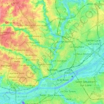
Name: Nantes topographic map, elevation, terrain.
Average elevation: 26 m
Minimum elevation: -32 m
Maximum elevation: 70 m
Nantes is built on the Armorican Massif, a range of weathered mountains which may be considered the backbone of Brittany. The mountains, stretching from the end of the Breton peninsula to the outskirts of the sedimentary Paris Basin, are composed of several parallel ridges of Ordovician and Cadomian rocks. Nantes is where one of these ridges, the Sillon de Bretagne, meets the Loire. It passes through the western end of the old town, forming a series of cliffs above the quays. The end of the ridge, the Butte Sainte-Anne, is a natural landmark 38 metres (125 feet) above sea level; its foothills are at an elevation of 15 metres (49 feet).
Other topographic maps
Click on a map to view its topography, its elevation and its terrain.
Batz-sur-Mer
France > Pays de la Loire > Loire-Atlantique
Batz-sur-Mer, Saint-Nazaire, Loire-Atlantique, Pays de la Loire, Metropolitan France, 44740, France
Average elevation: 2 m