
Make a donation
Gear up for your next adventure:
As an Amazon Associate, this site earns from qualifying purchases at no extra cost to you.
Latvia topographic map
Click on the map to display elevation.
Make a donation
Gear up for your next adventure:
As an Amazon Associate, this site earns from qualifying purchases at no extra cost to you.
Latvia
Coastal regions, especially the western coast of the Courland Peninsula, possess a more maritime climate with cooler summers and milder winters, while eastern parts exhibit a more continental climate with warmer summers and harsher winters. Nevertheless, the temperature variations are little as the territory of Latvia is relatively small. Moreover, Latvia's terrain is particularly flat (no more than 350 meters high), thus the Latvian climate is not differentiated by altitude.
Make a donation
Gear up for your next adventure:
As an Amazon Associate, this site earns from qualifying purchases at no extra cost to you.
About this map
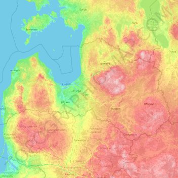
Name: Latvia topographic map, elevation, terrain.
Location: Latvia (55.67465 20.60099 58.08557 28.24149)
Average elevation: 72 m
Minimum elevation: -3 m
Maximum elevation: 289 m
Make a donation
Gear up for your next adventure:
As an Amazon Associate, this site earns from qualifying purchases at no extra cost to you.
Other topographic maps
Click on a map to view its topography, its elevation and its terrain.
Tbilisi
Most of the raions are named after historic quarters of the city. The citizens of Tbilisi widely recognise an informal system of smaller historic neighbourhoods. Such neighbourhoods are several, however, constituting a kind of hierarchy, because most of them have lost their distinctive topographic limits. The…
Average elevation: 713 m
Make a donation
Gear up for your next adventure:
As an Amazon Associate, this site earns from qualifying purchases at no extra cost to you.
Make a donation
Gear up for your next adventure:
As an Amazon Associate, this site earns from qualifying purchases at no extra cost to you.
Make a donation
Gear up for your next adventure:
As an Amazon Associate, this site earns from qualifying purchases at no extra cost to you.
Make a donation
Gear up for your next adventure:
As an Amazon Associate, this site earns from qualifying purchases at no extra cost to you.
Make a donation
Gear up for your next adventure:
As an Amazon Associate, this site earns from qualifying purchases at no extra cost to you.
Make a donation
Gear up for your next adventure:
As an Amazon Associate, this site earns from qualifying purchases at no extra cost to you.
Make a donation
Gear up for your next adventure:
As an Amazon Associate, this site earns from qualifying purchases at no extra cost to you.
Make a donation
Gear up for your next adventure:
As an Amazon Associate, this site earns from qualifying purchases at no extra cost to you.
Make a donation
Gear up for your next adventure:
As an Amazon Associate, this site earns from qualifying purchases at no extra cost to you.
Make a donation
Gear up for your next adventure:
As an Amazon Associate, this site earns from qualifying purchases at no extra cost to you.
Make a donation
Gear up for your next adventure:
As an Amazon Associate, this site earns from qualifying purchases at no extra cost to you.
Make a donation
Gear up for your next adventure:
As an Amazon Associate, this site earns from qualifying purchases at no extra cost to you.
Make a donation
Gear up for your next adventure:
As an Amazon Associate, this site earns from qualifying purchases at no extra cost to you.
Make a donation
Gear up for your next adventure:
As an Amazon Associate, this site earns from qualifying purchases at no extra cost to you.
Make a donation
Gear up for your next adventure:
As an Amazon Associate, this site earns from qualifying purchases at no extra cost to you.
Great Skellig
The island is of special interest to archaeologists, as the monastic settlement is in unusually good condition. The monastery on the northern peak is situated at an elevation of 170 to 180 m (550 to 600 ft), Christ's Saddle at 129 m (422 ft), and the flagstaff area are 37 m (120 ft) above sea level. The…
Average elevation: 1 m
Make a donation
Gear up for your next adventure:
As an Amazon Associate, this site earns from qualifying purchases at no extra cost to you.
Lambay Island
Lambay Island is the largest island off the east coast of Ireland. It covers about 2.5 km2 (0.97 sq mi). The highest point – a hill known as Knockbane – rises to 126 m (413 ft). The island's high ground lies to the east and aside from Knockbane includes Heath Hill and Tinian Hill, and in the extreme…
Average elevation: 14 m
Make a donation
Gear up for your next adventure:
As an Amazon Associate, this site earns from qualifying purchases at no extra cost to you.
Make a donation
Gear up for your next adventure:
As an Amazon Associate, this site earns from qualifying purchases at no extra cost to you.
Make a donation
Gear up for your next adventure:
As an Amazon Associate, this site earns from qualifying purchases at no extra cost to you.
Make a donation
Gear up for your next adventure:
As an Amazon Associate, this site earns from qualifying purchases at no extra cost to you.
Make a donation
Gear up for your next adventure:
As an Amazon Associate, this site earns from qualifying purchases at no extra cost to you.
Lugnaquilla
Lugnaquilla is the 432nd-highest and 21st most prominent mountain in Britain and Ireland, on the Simms classification. It is regarded by the Scottish Mountaineering Club (SMC) as one of 34 Furths, which is a mountain above 3,000 ft (914 m) in elevation, and meets the other SMC criteria for a Munro (e.g.…
Average elevation: 696 m
Make a donation
Gear up for your next adventure:
As an Amazon Associate, this site earns from qualifying purchases at no extra cost to you.
Knocknapeasta
It is the 231st-highest mountain in Britain and Ireland on the Simm classification. Cnoc na Péiste is regarded by the Scottish Mountaineering Club ("SMC") as one of 34 Furths, which is a mountain above 3,000 ft (914.4 m) in elevation, and meets the other SMC criteria for a Munro (e.g. "sufficient…
Average elevation: 579 m
Caher
Caher is the 200th–highest mountain in Britain and Ireland on the Simm classification. Caher is regarded by the Scottish Mountaineering Club ("SMC") as one of 34 Furths, which is a mountain above 3,000 ft (914.4 m) in elevation, and meets the other SMC criteria for a Munro (e.g. "sufficient separation"), but…
Average elevation: 617 m
Beenkeragh
Beenkeragh is the second-highest peak in Ireland, on both the Arderin and Vandeleur-Lynam lists. It is the 179th-highest mountain in Britain and Ireland on the Simm classification. Beenkeragh is regarded by the Scottish Mountaineering Club ("SMC") as one of 34 Furths, which is a mountain above 3,000 ft (914 m)…
Average elevation: 654 m
Make a donation
Gear up for your next adventure:
As an Amazon Associate, this site earns from qualifying purchases at no extra cost to you.
Musandam
The rugged coastline resembles the glacier-carved coasts of polar regions, but in this case, the coast was shaped by the movement of Earth's crust. The Arabian Plate is slowly pushing under the Eurasian Plate, creating the earthquake-prone mountains of Iran. On the leading edge of the Arabian Plate, the…
Average elevation: 254 m
Make a donation
Gear up for your next adventure:
As an Amazon Associate, this site earns from qualifying purchases at no extra cost to you.
Bruree
Ireland > County Limerick > The Municipal District of Cappamore — Kilmallock
Average elevation: 62 m
Watergrasshill
According to A Topographical Dictionary of Ireland, published by Samuel Lewis in 1837, Watergrasshill then had a population of 533 people.
Average elevation: 164 m
Make a donation
Gear up for your next adventure:
As an Amazon Associate, this site earns from qualifying purchases at no extra cost to you.