
Austria topographic map
Interactive map
Click on the map to display elevation.
About this map
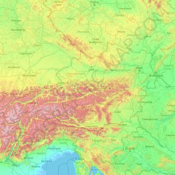
Name: Austria topographic map, elevation, terrain.
Location: Austria (46.37230 9.53075 49.02052 17.16077)
Average elevation: 595 m
Minimum elevation: -5 m
Maximum elevation: 3,694 m
The right for bilingual topographic signs for the regions where Slovene and Croat Austrians live alongside the German-speaking population (as required by the 1955 State Treaty) is still to be fully implemented in the view of some, while others believe that the treaty-derived obligations have been met (see below). Many Carinthians are afraid of Slovenian territorial claims, pointing to the fact that Yugoslav troops entered the state after each of the two World Wars and considering that some official Slovenian atlases show parts of Carinthia as Slovene cultural territory. The recently deceased governor, Jörg Haider, has made this fact a matter of public argument in autumn 2005 by refusing to increase the number of bilingual topographic signs in Carinthia. A poll by the Kärntner Humaninstitut conducted in January 2006 states that 65% of Carinthians are not in favour of an increase of bilingual topographic signs, since the original requirements set by the State Treaty of 1955 have already been fulfilled according to their point of view.
Other topographic maps
Click on a map to view its topography, its elevation and its terrain.
Ireland
Ireland
Average elevation: 44 m
Chasiv Yar
Chasiv Yar, Chasiv Yar Urban Hromada, Bakhmut Raion, Donetsk Oblast, 84551-84556, Ukraine
Average elevation: 213 m
Croatia
Croatia
Average elevation: 323 m
Czechia
Czechia
Average elevation: 369 m
Cork
Ireland > County Cork > Cork
Cork, County Cork, Munster, T12 T997, Ireland
Average elevation: 94 m
Galway City
Galway, Galway City, County Galway, Connacht, H91 YD86, Ireland
Average elevation: 26 m
Bangladesh
Bangladesh
Average elevation: 161 m
Monterey County
Monterey County, California, United States
Average elevation: 282 m
San Bernardino County
San Bernardino County, California, United States
Average elevation: 763 m
El Dorado County
El Dorado County, California, United States
Average elevation: 1,286 m
Europe
Europe
Average elevation: 223 m
Taiwan
Taiwan > Taiwan Province > Xinyi Township
Taiwan, Xinyi Township, Nantou County, Taiwan Province, Taiwan
Average elevation: 196 m
Markaryds kommun
Markaryds kommun, Kronoberg County, Sweden
Average elevation: 137 m
Ryhill
United Kingdom > England > Wakefield
Ryhill, Wakefield, West Yorkshire, England, United Kingdom
Average elevation: 76 m
Kilkenny
Kilkenny, The Municipal District of Kilkenny City, County Kilkenny, Leinster, Ireland
Average elevation: 61 m
Bad Krozingen
Germany > Baden-Württemberg > Landkreis Breisgau-Hochschwarzwald
Bad Krozingen, VVG der Stadt Bad Krozingen, Landkreis Breisgau-Hochschwarzwald, Baden-Württemberg, Germany
Average elevation: 243 m
Madagascar
Madagascar
Average elevation: 139 m
West Lulworth
United Kingdom > England > Dorset
West Lulworth, Dorset, England, United Kingdom
Average elevation: 84 m
Serrano Village
United States > California > San Bernardino County > San Bernardino
Serrano Village, San Bernardino, San Bernardino County, California, 92405, United States
Average elevation: 489 m
Chatsworth
Canada > Ontario > Grey County
Chatsworth, Grey County, Ontario, Canada
Average elevation: 317 m
Vauconcourt-Nervezain
France > Bourgogne – Franche-Comté > Haute-Saône
Vauconcourt-Nervezain, Vesoul, Haute-Saône, Bourgogne – Franche-Comté, Metropolitan France, 70120, France
Average elevation: 243 m
Cordarragh
Cordarragh, Headford ED, Tuam Municipal District, County Galway, Connacht, Ireland
Average elevation: 20 m
Victorville
United States > California > San Bernardino County
Victorville, San Bernardino County, California, United States
Average elevation: 920 m
Eystrup
Germany > Lower Saxony > Landkreis Nienburg/Weser
Eystrup, Samtgemeinde Grafschaft Hoya, Landkreis Nienburg/Weser, Lower Saxony, 27324, Germany
Average elevation: 21 m
Helena
United States > Montana > Lewis and Clark County
Helena, Lewis and Clark County, Montana, United States
Average elevation: 1,296 m
Comeragh
Comeragh, The Municipal District of Comeragh, County Waterford, Munster, Ireland
Average elevation: 215 m
Miłomłyn
Poland > Warmian-Masurian Voivodeship > Ostróda County
Miłomłyn, gmina Miłomłyn, Ostróda County, Warmian-Masurian Voivodeship, 14-140, Poland
Average elevation: 109 m
El Salvador
El Salvador
Average elevation: 484 m
Latvia
Latvia
Average elevation: 72 m
Swilla Glen
United Kingdom > England > North Yorkshire > Thornton in Lonsdale
Swilla Glen, Thornton in Lonsdale, North Yorkshire, England, LA6 3JJ, United Kingdom
Average elevation: 204 m
Ingleton
United Kingdom > England > North Yorkshire
Ingleton, North Yorkshire, England, United Kingdom
Average elevation: 309 m
Ballincollig
Ireland > County Cork > Cork
Ballincollig, Cork, County Cork, Munster, P31 TW88, Ireland
Average elevation: 62 m