
Auckland topographic map
Interactive map
Click on the map to display elevation.
About this map
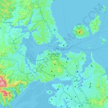
Name: Auckland topographic map, elevation, terrain.
Location: Auckland, Waitematā, Auckland, 1010, New Zealand (-37.01210 174.60318 -36.69210 174.92318)
Average elevation: 32 m
Minimum elevation: -2 m
Maximum elevation: 394 m
The Auckland Volcanic Field has contributed greatly to the growth and prosperity of the Auckland Region since the area was settled by humans. Initially, the maunga (scoria cones) were occupied and established as pā (fortified settlements) by Māori due to the strategic advantage their elevation provided in controlling resources and key portages between the Waitematā and Manukau harbours. The rich volcanic soils found in these areas also proved ideal for the cultivation of crops, such as kūmara. Following European arrival, many of the maunga were transformed into quarries to supply the growing city with aggregate and building materials, and as a result were severely damaged or entirely destroyed. A number of the smaller maar craters and tuff rings were also removed during earthworks. Most of the remaining volcanic centres are now preserved within recreational reserves administered by Auckland Council, the Department of Conservation, and the Tūpuna Maunga o Tāmaki Makaurau Authority.
Other topographic maps
Click on a map to view its topography, its elevation and its terrain.
Omaha Beach
New Zealand > Auckland > Rodney > Omaha
Omaha Beach, Omaha, Rodney, Auckland, New Zealand
Average elevation: 3 m
Runciman
New Zealand > Auckland > Franklin > Runciman
Runciman, Franklin, Auckland, 2578, New Zealand
Average elevation: 20 m
Hibiscus Coast
New Zealand > Auckland > Hibiscus Coast
Hibiscus Coast, Hibiscus and Bays, Auckland, 0932, New Zealand
Average elevation: 40 m
Little Barrier Island
New Zealand > Auckland > Aotea Great Barrier
Little Barrier Island, Aotea Great Barrier, Auckland, New Zealand
Average elevation: 145 m