
Scotland topographic map
Interactive map
Click on the map to display elevation.
About this map
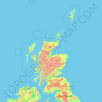
Name: Scotland topographic map, elevation, terrain.
Location: Scotland, United Kingdom (54.43398 -14.01552 61.06100 -0.32092)
Average elevation: 36 m
Minimum elevation: 0 m
Maximum elevation: 1,259 m
A significant exception to the above are the fossil-bearing beds of Old Red Sandstones found principally along the Moray Firth coast. The Highlands are generally mountainous and the highest elevations in the British Isles are found here. Scotland has over 790 islands divided into four main groups: Shetland, Orkney, and the Inner Hebrides and Outer Hebrides. There are numerous bodies of freshwater including Loch Lomond and Loch Ness. Some parts of the coastline consist of machair, a low-lying dune pasture land.
Other topographic maps
Click on a map to view its topography, its elevation and its terrain.
West Lulworth
United Kingdom > England > Dorset
West Lulworth, Dorset, England, United Kingdom
Average elevation: 84 m
High Wycombe
United Kingdom > England > Buckinghamshire
High Wycombe, Buckinghamshire, England, United Kingdom
Average elevation: 124 m
Egham
United Kingdom > England > Surrey > Borough of Runnymede
Egham, Borough of Runnymede, Surrey, England, United Kingdom
Average elevation: 25 m
Bradford
Bradford, West Yorkshire, England, United Kingdom
Average elevation: 175 m
Millport
United Kingdom > Scotland > North Ayrshire
Millport, North Ayrshire, Scotland, KA28 0DL, United Kingdom
Average elevation: 11 m
Cornwall
United Kingdom > England > Fairy Cross
Cornwall, Broadoak, Fairy Cross, Cornwall, South West England, England, United Kingdom
Average elevation: 49 m
Malvern
United Kingdom > England > Worcestershire > Malvern Hills
Malvern, Malvern Hills, Worcestershire, England, WR14 2HX, United Kingdom
Average elevation: 95 m
Swindon
United Kingdom > England > Swindon
Swindon, England, SN1 1LF, United Kingdom
Average elevation: 108 m
Headley
United Kingdom > England > Surrey > Mole Valley
Headley, Mole Valley, Surrey, England, United Kingdom
Average elevation: 146 m
Antrim
United Kingdom > Northern Ireland > County Antrim
Antrim, County Antrim, Northern Ireland, BT41 4AR, United Kingdom
Average elevation: 50 m
Birmingham
Birmingham, West Midlands Combined Authority, England, United Kingdom
Average elevation: 138 m
Wakefield
Wakefield, West Yorkshire, England, United Kingdom
Average elevation: 88 m
Bedgebury National Pinetum
United Kingdom > England > Kent > Tunbridge Wells > Kilndown
Bedgebury National Pinetum, Goudhurst, Kilndown, Tunbridge Wells, Kent, England, United Kingdom
Average elevation: 91 m
Knole Park (Deer Park)
United Kingdom > England > Kent > Sevenoaks > Sevenoaks Weald
Knole Park (Deer Park), Sevenoaks Weald, Sevenoaks, Kent, England, United Kingdom
Average elevation: 161 m
Richmond Park
United Kingdom > England > London
Richmond Park, London Borough of Richmond upon Thames, London, Greater London, England, United Kingdom
Average elevation: 26 m
Middlesbrough
United Kingdom > England > Middlesbrough
Middlesbrough, Tees Valley, England, United Kingdom
Average elevation: 26 m
Droitwich Spa
United Kingdom > England > Worcestershire > Wychavon
Droitwich Spa, Wychavon, Worcestershire, England, WR9 8DY, United Kingdom
Average elevation: 49 m
Charlbury
United Kingdom > England > Oxfordshire > West Oxfordshire > Charlbury
Charlbury, West Oxfordshire, Oxfordshire, England, United Kingdom
Average elevation: 132 m
Carnlough
United Kingdom > Northern Ireland > County Antrim
Carnlough, County Antrim, Northern Ireland, BT44 0EU, United Kingdom
Average elevation: 77 m
Drains Bay
United Kingdom > Northern Ireland > County Antrim
Drains Bay, County Antrim, Northern Ireland, BT40 2LG, United Kingdom
Average elevation: 38 m
Sledge Green
United Kingdom > England > Worcestershire > Malvern Hills > Pendock
Sledge Green, Pendock, Malvern Hills, Worcestershire, England, WR13 6JP, United Kingdom
Average elevation: 21 m
Hatfield
United Kingdom > England > Hertfordshire > Welwyn Hatfield
Hatfield, Welwyn Hatfield, Hertfordshire, England, United Kingdom
Average elevation: 90 m
Cheddar
United Kingdom > England > Somerset
Cheddar, Somerset, England, United Kingdom
Average elevation: 109 m
Pumsaint
United Kingdom > Wales > Carmarthenshire
Pumsaint, Carmarthenshire, Wales, SA19 8YT, United Kingdom
Average elevation: 181 m
Aberporth
United Kingdom > Wales > Ceredigion
Aberporth, Ceredigion, Wales, SA43 2DB, United Kingdom
Average elevation: 62 m
Stow
United Kingdom > Scotland > Scottish Borders
Stow, Scottish Borders, Scotland, TD1 2RE, United Kingdom
Average elevation: 268 m
Droghed
United Kingdom > Northern Ireland
Droghed, Northern Ireland, United Kingdom
Average elevation: 16 m
Stob Choire Claurigh
United Kingdom > Scotland > Highland
Stob Choire Claurigh, Highland, Scotland, United Kingdom
Average elevation: 852 m
Aonach Beag
United Kingdom > Scotland > Highland
Aonach Beag, Highland, Scotland, United Kingdom
Average elevation: 825 m
Ballachulish
United Kingdom > Scotland > Highland
Ballachulish, Highland, Scotland, PH49 4JU, United Kingdom
Average elevation: 160 m
Trimpley Green
United Kingdom > England > Worcestershire > Wyre Forest
Trimpley Green, Kidderminster Foreign, Wyre Forest, Worcestershire, England, United Kingdom
Average elevation: 113 m
Ben Cleuch
United Kingdom > Scotland > Clackmannanshire
Ben Cleuch, Clackmannanshire, Scotland, FK12 5HU, United Kingdom
Average elevation: 555 m
Fingland
United Kingdom > Scotland > Dumfries and Galloway
Fingland, Dumfries and Galloway, Scotland, DG11 2LD, United Kingdom
Average elevation: 206 m
Loch Lochy
United Kingdom > Scotland > Highland
Loch Lochy, Highland, Scotland, United Kingdom
Average elevation: 363 m
Roybridge
United Kingdom > Scotland > Highland
Roybridge, Highland, Scotland, PH31 4AE, United Kingdom
Average elevation: 178 m
Seang Aonach Mor
United Kingdom > Scotland > Highland
Seang Aonach Mor, Highland, Scotland, United Kingdom
Average elevation: 895 m
Aonach Mòr
United Kingdom > Scotland > Highland
Aonach Mòr, Highland, Scotland, United Kingdom
Average elevation: 533 m
Inverroy
United Kingdom > Scotland > Highland
Inverroy, Highland, Scotland, PH31 4AQ, United Kingdom
Average elevation: 167 m
Glen Nevis
United Kingdom > Scotland > Highland
Glen Nevis, Highland, Scotland, PH33 6TE, United Kingdom
Average elevation: 178 m
Strathcarron
United Kingdom > Scotland > Highland
Strathcarron, Highland, Scotland, IV54 8YR, United Kingdom
Average elevation: 91 m
Cheltenham
United Kingdom > England > Gloucestershire
Cheltenham, Gloucestershire, England, United Kingdom
Average elevation: 109 m
Blacklaw
United Kingdom > Scotland > Scottish Borders
Blacklaw, Scottish Borders, Scotland, ML12 6QR, United Kingdom
Average elevation: 360 m
Chapel Brampton
United Kingdom > England > West Northamptonshire
Chapel Brampton, West Northamptonshire, England, NN6 8AF, United Kingdom
Average elevation: 91 m
Slaley
United Kingdom > England > Northumberland
Slaley, Northumberland, North of Tyne, England, United Kingdom
Average elevation: 210 m
Meltham
United Kingdom > England > Kirklees
Meltham, Kirklees, West Yorkshire, England, United Kingdom
Average elevation: 278 m
Abbey St. Bathans
United Kingdom > Scotland > Scottish Borders
Abbey St. Bathans, Scottish Borders, Scotland, TD11 3TX, United Kingdom
Average elevation: 212 m
Quothquan
United Kingdom > Scotland > South Lanarkshire
Quothquan, South Lanarkshire, Scotland, ML12 6FP, United Kingdom
Average elevation: 244 m
Rochdale
Rochdale, Greater Manchester, England, United Kingdom
Average elevation: 223 m
Settle
United Kingdom > England > North Yorkshire
Settle, North Yorkshire, England, United Kingdom
Average elevation: 238 m