
Thank you for supporting this site ❤️
Make a donation
Make a donation
Gear up for your next adventure:
As an Amazon Associate, this site earns from qualifying purchases at no extra cost to you.
Épalinges topographic map
Click on the map to display elevation.
Thank you for supporting this site ❤️
Make a donation
Make a donation
Gear up for your next adventure:
As an Amazon Associate, this site earns from qualifying purchases at no extra cost to you.
About this map
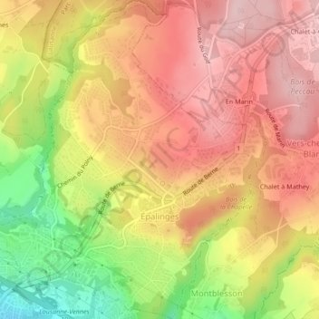
Name: Épalinges topographic map, elevation, terrain.
Location: Épalinges, District de Lausanne, Vaud, Switzerland (46.53798 6.64681 46.56680 6.68666)
Average elevation: 790 m
Minimum elevation: 658 m
Maximum elevation: 875 m
Thank you for supporting this site ❤️
Make a donation
Make a donation
Gear up for your next adventure:
As an Amazon Associate, this site earns from qualifying purchases at no extra cost to you.