
Vojvodina topographic map
Interactive map
Click on the map to display elevation.
About this map
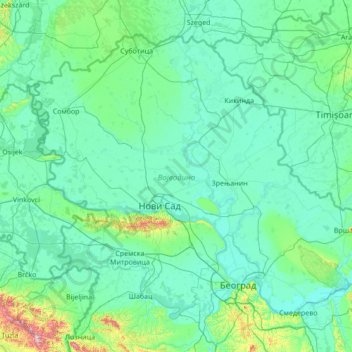
Name: Vojvodina topographic map, elevation, terrain.
Location: Vojvodina, Serbia (44.62973 18.81499 46.19028 21.56013)
Average elevation: 110 m
Minimum elevation: 66 m
Maximum elevation: 860 m
Today, the western part of Syrmia is in Croatia, the northern part of Bačka is in Hungary, the eastern part of Banat is in Romania (with a small piece in Hungary), while Baranja (which is between the Danube and the Drava) is in Hungary and Croatia. Vojvodina has a total surface area of 21,500 km2 (8,300 sq mi). Vojvodina is also part of the Danube-Kris-Mures-Tisa euroregion. The Gudurica peak (Gudurički vrh) on the Vršac Mountains, is the highest peak in Vojvodina, at an altitude of 641 m above sea level.
Other topographic maps
Click on a map to view its topography, its elevation and its terrain.
Uvac
Serbia > Central Serbia > Zlatibor Administrative District > Nova Varos Municipality
Uvac, Nova Varos Municipality, Zlatibor Administrative District, Central Serbia, Serbia
Average elevation: 1,146 m
Moravac
Serbia > Central Serbia > Nisava Administrative District > Aleksinac Municipality
Moravac, Aleksinac Municipality, Nisava Administrative District, Central Serbia, 18210, Serbia
Average elevation: 176 m
Kragujevac
Serbia > Central Serbia > Sumadija Administrative District
Kragujevac, City of Kragujevac, Sumadija Administrative District, Central Serbia, 34114, Serbia
Average elevation: 320 m
Surcin Urban Municipality
Serbia > Central Serbia > City of Belgrade
Surcin Urban Municipality, City of Belgrade, Central Serbia, Serbia
Average elevation: 84 m
Cerovac
Serbia > Central Serbia > Macva Administrative District
Cerovac, Macva Administrative District, Central Serbia, Serbia
Average elevation: 104 m
Kosmaj
Serbia > Central Serbia > City of Belgrade > Sopot Urban Municipality
Kosmaj, Sopot Urban Municipality, City of Belgrade, Central Serbia, Serbia
Average elevation: 398 m
Belgrade
Serbia > Central Serbia > City of Belgrade
Belgrade, City of Belgrade, Central Serbia, 11000, Serbia
Average elevation: 108 m
Crna Reka
Serbia > Central Serbia > Pcinja Administrative District > Trgoviste Municipality
Crna Reka, Trgoviste Municipality, Pcinja Administrative District, Central Serbia, Serbia
Average elevation: 1,449 m
Serbia
Serbia > Central Serbia > Kragujevac
Serbia, Donje Komarice, Kragujevac, Kragujevac City, Sumadija Administrative District, Central Serbia, Serbia
Average elevation: 518 m
Besna Kobila
Besna Kobila, Vranje City, Pcinja Administrative District, Central Serbia, Serbia
Average elevation: 1,612 m
Tennis Courts
Serbia > Central Serbia > Paracin Municipality
Tennis Courts, Glavica, Paracin Municipality, Pomoravlje Administrative District, Central Serbia, Serbia
Average elevation: 212 m
Caricina
Serbia > Central Serbia > Царичина
Caricina, Царичина, Zlatibor Administrative District, Central Serbia, Serbia
Average elevation: 1,345 m